43: A walk down Garner's Lane
Farm track to main road - compiled by Charlie Hulme
Davenport Station home | Index to History pages
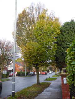
Garner's Lane, which connects Davenport with Adswood, is today a busy road leading from Bramhall Lane to Cheadle and a link to the Motorway network, but until the 1800s it was just a track leading to a farm. On this page I try to trace its history and some notable people and events. As usual, there are some 'loose ends'; comments and corrections are welcome.
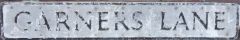
The street-sign for Garner's Lane, has no apostrophe; this is not an error, but a convention for such signs. The style of lettering used by Stockport and many other towns after World War 2 ; Many older plates were removed in the war in attempt to confuse invading troops. The letter style is known as 'Kindersley' after its designer. It is one of the few remaining plates made by the 'die-pressed' method.
The Mitchells
It's a good time to write more about the creators of the map seen here. The Mitchells' maps of Heald Green, Cheadle, Gatley, Cheadle Hulme, Bramhall and elsewhere, which have been sold by Stockport Library for many years, have been the mainstay of many people's local history efforts.
The hand-drawn work must have taken many hours of poring over the (hardly legible in some cases) original Tithe Maps, research and painstaking writing freehand. Teretta, born Teretta May Galey in 1910, who we believe did the artistry, was a daughter of John Galey, a Manchester shop assistant, and his wife Teretta, who hailed from the Isle of Man, perhaps explaining the unusual forename.
Terrata May Galey married Frank Mitchell in 1948, and in the 1960s Terrata became the archivist of St James Church, Gatley, where her collection is stored and has recently been digitised. The work of the Mitchells, who I believe died in the 1980s, should be celebrated at every opportunity.
The Aviator
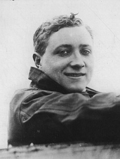
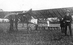
Great excitement in the Garners Lane area was to be seen in September 1913 when Bates Ley Farm briefly became an airfield. Gustav Hamel, a German-born British subject brought his flying display to Stockport for two days.
We have transcribed the newspaper advert below.
ENGLAND'S PREMIER AVIATOR TO VISIT
STOCKPORT
MR. GUSTAV HAMEL
(THE WORLD-RENOWNED AIRMAN)
WILL GIVE
FLYING & PASSENGER CARRYING EXHIBITIONS
Using his Latest Type of 80-h.p. Double-seater BLERIOT MONOPLANE
AT BATES LEY FARM,
GARNER'S LANE,
ADSWOOD
on the land of Mr Goodall within a few minutes' walk of Davenport and Cheadle Hulme stations, L and W.R.Railway, and Tram Cars.
On THURSDAY and SATURDAY NEXT, Sept. 4th and 6th, 1913.
FLIGHTS from 3 to 6.30 each day.
Admission: Thursday 1s. : Saturday 6d. Reserved enclosure 1s. Motor Cards (including driver) 2s. Intending passengers can book a seat on the Flying Ground at the advertised times.
It seems that few passengers had the experience of
flight: one source records that he made just two 15-minute
flights on each of the two days.MR. GUSTAV HAMEL
(THE WORLD-RENOWNED AIRMAN)
WILL GIVE
FLYING & PASSENGER CARRYING EXHIBITIONS
Using his Latest Type of 80-h.p. Double-seater BLERIOT MONOPLANE
AT BATES LEY FARM,
GARNER'S LANE,
ADSWOOD
on the land of Mr Goodall within a few minutes' walk of Davenport and Cheadle Hulme stations, L and W.R.Railway, and Tram Cars.
On THURSDAY and SATURDAY NEXT, Sept. 4th and 6th, 1913.
FLIGHTS from 3 to 6.30 each day.
Admission: Thursday 1s. : Saturday 6d. Reserved enclosure 1s. Motor Cards (including driver) 2s. Intending passengers can book a seat on the Flying Ground at the advertised times.
At the time, Hamel was touring the country with his plane. Sadly he did not live to beccome an flying ace in World War One. In May 19i4 he disappeared, aged 24, while flying a new aircraft from France. His body was found in the Channel a few months later.
The flying bomb
In the early hours of Christmas Eve 1944, Heinkel bombers flying over the North Sea launched their V-1 flying bombs. Most landed east of the Pennines, but one reached Stockport before landing and exploding on the golf course behind the semi-detached house nos 87 and 89 Garner's Lane, wrecking that building beyond repair, and causing a crater 50 feet across, and damage spread over a wide area. The pressure wave blew out the windows and doors of around 300 houses . US troops stationed in Stockport - the garages in nearby Oakfield Road had been commandeered for their use - assisted in the rescue and clearing work.
Fortunately there were few life-threatening injuries, except for William Etchells, who lived with his family at no. 87, who was freed from the wreckage with severe head injuries. Credited with saving the life of his granddaughter, died in hospital on 5 January 1945. The Mayor of Stockport promised his widow that a new house would be built, and the families were able to move in ten weeks later. Joseph Briscoe at no.71 Garners Lane was already ill, but the bombing no doubt hasted his death.
30 flying bombs, fell on northern England that day and night, spread randomly over a wide area, centered on Manchester. Another fell in Didsbury. The bombs were not controlled; each carried a measured amount of fuel, and when the fuel ran out they fell to the ground and exploded.
The raid has been well-documented, especially by a book written by Peter J.C. Smith entitled Flying Bombs over the Pennines published in 1988 by Neil Richardson, and online, the Air Crash Sites website which has a detailed record with some interesting comments.
The Garners
William Garner's 'family tree' entries preceding his birth is proving difficult to assemble. We do know that William was born around 1775, the father of Owen Garner, farmer and landlord of the Tatton Arms inn in the hamlet of Moss Nook, an establishment which still thrives in 2023, in the proximity of Manchester Airport.
The Unsworths
Newton Unsworth was born in 1818 in Carrington, Cheshire, the eldest son of Thomas Unsworth, a Carrington farmer, and his wife Hannah. The 1841 census records seven children of Thomas and Hannah: Newton (aged 14), Sarah (12), Thomas (9), William (6), Alice (5), John (3) and George (2). One of the farmhands was Thomas Woodall, a name which appears later in the story.
The 1851 census found Newton (aged 23) running Bates Ley with his wife Sarah, his son William (aged 2), two house servants, three farm servants and a milk boy. In 1861 the household was similar, although his son Thomas (aged 9) is listed. William had died, aged 12, just after the 1861 census.
By 1871 Newton had removed with his family to Old Hall Farm, Ashton-on-Mersey near his birthplace in Carrington. He died in 1894, and is buried at St Georges Church, Carrington. Sarah died the following year.
Garner again?
A William Garner appears as 'Farmer, Adswood' in 1870s and 1883 Directories. Bates Ley is not named in the lists, but this may have been William Garner, son of Owen Garner. I cannot prove this at present, however. He was 42 in 1871, living at his father Owen's farm in Northen Etchells, so it is feasible that he took over Bates Ley from Newton Unsworth.
Another son of Owen, Thomas Garner (1830-1916) was tenant of New House Farm in Bramhall; this remained in the Garner family as a working farm until the 1970s when it was replaced by a housing estate of the same name.
The Woodalls
The Woodall family farmed in the grounds of Abney Hall in Cheadle before moving to Bates Ley around 1899.The household at Bates Ley in 1901 comprised Thomas Lewis Woodall (head, farmer born in 1855, age 46), his wife Ann Woodall (45), sons Thomas Lewis Woodall (16), Samuel Venables Woodall (10), Ellen Venables (niece, 23), Margaret Venables (niece, 15) and Ann Venables (sister-in-law, 40). The Venables ladies were listed as 'domestic servants'.
By 1911 the eldest son, also named
Thomas Lewis Woodall [2nd], born in 1885, had a farm of
his own, Linney's Tenement Farm in Bramhall, where he
lived with his wife Ellen Woodall and his
son, Thomas Lewis Woodall [3rd, born 1916). The
1921 Census for Tenement Farm also lists three daughters,
Norah, Margaret and Alice.
Thomas Lewis Woodall (2nd,born 1885) was at Lion House Farm on Ladybridge Road, when he died in 1965. Thomas Lewis Woodall ( [3rd, born in 1916) lived until 2005, latterly in the High Peak of Derbyshire.
Samuel Venables Woodall worked with his father lodging at
the farmer for 10 shillings per week in 1914. He retired
with his family to a house in the Prestatyn area of Wales
which he named 'Bates Ley'. He died in 1960. Thomas Lewis Woodall (2nd,born 1885) was at Lion House Farm on Ladybridge Road, when he died in 1965. Thomas Lewis Woodall ( [3rd, born in 1916) lived until 2005, latterly in the High Peak of Derbyshire.
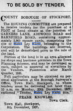
Thomas Lewis Woodall [1st, born 1855) stayed at Bates Ley; the farmhouse remained standing when the rest of the land was no longer farmed. After his death in 1937 the farmhouse, by then owned by Stockport Corporation was offered for sale,
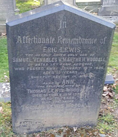
This grave in Cheadle Cemetery records the deaths of Eric Lewis Woodall, son of Samuel and Martha, who died in 1925 aged just 15; Ann, the wife of Thomas Lewis Woodall [1st], died 1923 aged 74; Thomas Lewis Woodall [1st], died 1937; and Samuel Venables Woodall, died 1960.
Richard Whittaker
The earliest mention we have found in old newspapers is in the Manchester Mercury of 1781, which announces the sale of fifty oak trees from Bates Hey Farm, held by John Cooper of Adswood.
However, the farm was older than that. Sue Bailey's researches in surviving wills of tenant farmers of Bramhall include the will of Richard Whittaker of Bramall, dated 1592. The will does not name the farm, but does name the witnesses as 'Robert Bridge of Bridge Hall ... and Thomas Richardson of Addswood'. These names refer to Bridge Hall farm and Adswood Hall farm, both adjoining Bates Ley, which strongly suggests that the Whittakers lived at Bates Ley.
What have I not discovered after all this research is the full meaning of the name Bates Ley. 'Ley' according to the Oxford Dictionary is 'a piece of land put down to grass, clover, etc., for a single season or a limited number of years, in contrast to permanent pasture, but who was Mr Bate, or Bates?
From a Directory, 1905
Builder William Winbolt gave the first house to his son Harry.
1 Harry Winbolt
3 Arthur John Addy
5 John Owen
9 John Rigby
11 Samuel Withington
13 James Naylor
15 Alfred Atkinson
17 Joseph Taylor
19 Charles Hay
21 Mrs Ritson
23 Ernest Leigh
25 Henry Bell
31 John Harold Holt
33 Arthur Stockwell
37 Albert John King
The list ends here: further houses were houses yet to be built.
Heads of Households 1911-14
From the 1914 electoral register with additions from the 1911 census shown in brackets [ ].
* marks rented houses. Occupations given if confirmed,
1 Arthur John Addy Railway Clerk
3 Joseph Rathbone Thomstone Fancy Tailor
5 Mary Owen Teacher of Music *
7 William Henry Hussey Buyer (Corsets)
9 Joseph Moscrop Velveteen Salesman
[11 William Reynolds secretary cotton spinning firm]
11 William Plant
[13 Thomas Goodison Retired agent]
15 Alfred Hopkinson Cashier Railway Company*
17 Edwin Allcock Retired commerical traveller
19 Charles Hay Salesman
[21 Thomas Greene?] Railway Clerk
21 Arthur Forth Mercantile clerk
23 Samuel Hazeldine Commerical Clerk
[25 John T Barnett Wine and Spirit Merchant]
25 John Shannon
27 Martha Claridge *
29 unoccupied
31 Frank Crossley Salesman
33 William Atkinson
[33 Arthur Stockwell Export Shipping Clerk]
35 Arthur William Duncan analytical chemist
37 unoccupied
39 Frank Robinson Law stationer
41 Harold Wordsworth Milne Bank Clerk
43 Robert Loose
45 Thomas Percy Eckersall *
47 James Henry Unsworth Commission agent (?eggs)
49 Richard Williamson
51 Eliza Jane Jeffcoat Private means *
53 Charles Matthew Hargreaves Machine Leather driving belt maker
53 James Harradine Pateman Artist and designer
55 Frank Hayes
57 Willam Edward Bowers Taylor Linen
yarn agent
59 William Reed Bullivant joiner and builder
61 Fred Charles Turner general and machine export merchant
63 Albert John King Commercial traveller, engineers tools
65 Robert Barton Coloured woolen cloth merchant
67 Joseph Herbert Deacon Cotton goods merchant
69 Edward Hankinson Commercial clerk oil merchant
71 Frederick Walton Cloth agent Insurance inspector
73 Edward Percy Kidson Insurance inspector
Thomas Lewis Woodall Bates Ley farm
There were no other houses on Garner's Lane at this time.
'Farm to Let'
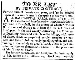
1804
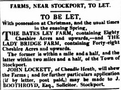
1831
1848
1848
1918 sale of Freehold
Letter to a newspaper, 1904
Dear Sir,- Will you kindly call attention to the disgraceful smell which one encounters in Garner's Lane, Davenport, Stockport, a little below the brickfield, and just past the new dwelling-houses.
This smell arises from a ditch which can be nothing less
than an open server.
The lake is a very popular one for young people, being a
really pretty walk between Cheadle and Davenport, but
under its present sanitary conditions I consider it an
absolute danger to any passer-by.
I believe the authorities have been repeatedly written-to,
but without any remedy being applied, so I ask you to give
this letter a portion of your space.
I understand now what a Scotsman means when he says "he
feels a smell."
I enclose my card. - T.S.A.
Sources
Ancestry.co.ukFindmypast.com
British Newspaper archive
Cheshire Tithe Maps
National Library of Scotland Ordnance Survey collection
timepix.uk
The Land Registry
Electoral Registers in Stockport Heritage Library (which is closed at the time of writing)
Street Directories in our
collection
Thanks to:
The residents of 63 Garners Lane
Sue Bailey for her book The Early Tenant Farmers of Bramhall (Privately published)
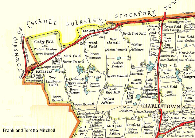
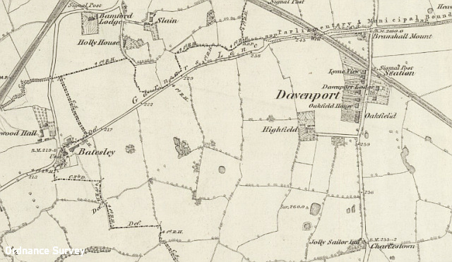
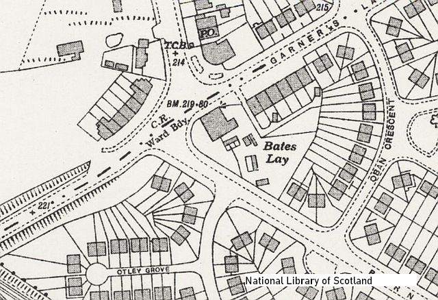
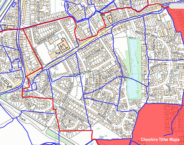
The best map we have of the Garner's Lane area as it was before the railway arrived is the transcription of the 1842 Tithe Map of north-west Bramhall, published in 1976 by Teretta and Frank Mitchell of Gatley; an extract is shown above. At that time, there was no such place as 'Davenport' - that came with the railway station. Newton Unsworth was the farmer at Bates Ley. The only settlement on the map is 'Charlestown' consisting of four cottages and a farmouse (later a pub.) One thing to note is that the street names are the modern ones; the Tithe Maps do not always give names. The name may have been Shotsall Lane, or Brock Lane. The current name commemorates a William Garner, who in the early 1800s presided over two farms: Bates Ley Farm and nearby Ladybridge Farm (or possibly a later relative with the same name.)
The eastern part of what became Garner's Lane may once have been considered part of Kennerley Grave Lane (see feature 42); it follows boundary between Stockport and Bramhall, then diverges, along a direct route away from the erratic boundary between Cheadle and Bramhall to the farm buildings of Batesley (or Bates Ley) and a junction with Adswood Lane. The census-taker of the day had a lonely walk to reach this outpost of the Davenports' Bramhall estates.
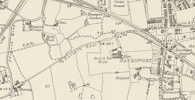
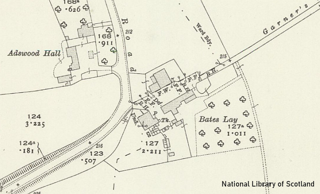
This Ordnance Survey map extract dated 1872 shows Garner's Lane still passing through open fields, although the large house, 'Bramall Mount', had been built at the junction of Garner's Lane and Bramhall Lane in the 1850s. The Stockport, Disley and Whaley Bridge Railway, opened in 1857, crossed Bramhall Lane by a bridge, whilst Garner's Lane was crossed on the level with a gated crossing. The map shows the hamlet of Davenport, built in response to the opening of the station, which had been built by the request of Colonel Davenport of Bramhall in return for crossing his land. For want of a name in the midst of fields, the station, opened in March 1858, was named Davenport. Few passengers appeared - possibly a few ramblers - and it was closed 'for the winter' in October 1859, and re-opened, to serve the houses which now existed, in May 1863. Following complaints about the gates blocking Garner's Lane , a small house was built adjacent to the Level Crossing, and became the home of the 'station agent'.
The London and North Western Railway, which had absorbed the Stockport, Disley and Whaley Bridge line, and extended it to Buxton, embarked in the 1880s on improvements to its stations and routes, in particular removing Level Crossings where possible. A new section of road, from opposite the station, enabling Garners' Lane traffic to cross the line by the Bramhall Lane bridge. (A similar alteration was made at Whaley Bridge, although Woodsmoor, Norbury and Furness Vale Level Crossings remain today, presumably too difficult to avoid.) The road-level booking office was also built at this time, and also a railway siding; see below.
More houses had been built in Davenport, but the track down to Bates Ley and the farm were unchanged. A plan relating to the sale shows Oakfield Road heading west in a straight line, but it was actually laid out parallel to Garners Lane as seen on the 1910 map.
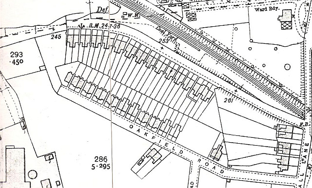
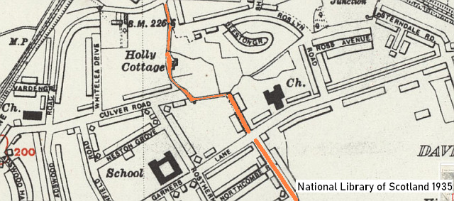
The 1910 map of the area shows how prolific local builder William Winbolt took advantage of the new road to create a row of houses on Garners Lane, and a row back on to them, creating Oakfield Road by extending what had been a farm track leading from Bramhall Lane. The land was leased from the Christy family, who had purchased it from the Davenports. The Winbolt houses were apparenly built in two stages. This 1910 map shows that only houses 1-61 had been built at that time.
Originally Oakfield Road did not extend to Garners Lane; the is was remedied by the laying out of Elmfield Road, with another long line of Winbolt houses on its west side as well as a further row on Garner's Lane, 63-71, in a diferent style without the T-shape plan of earlier construction. Houses were built, by various other builders, in the island created by the three roads.
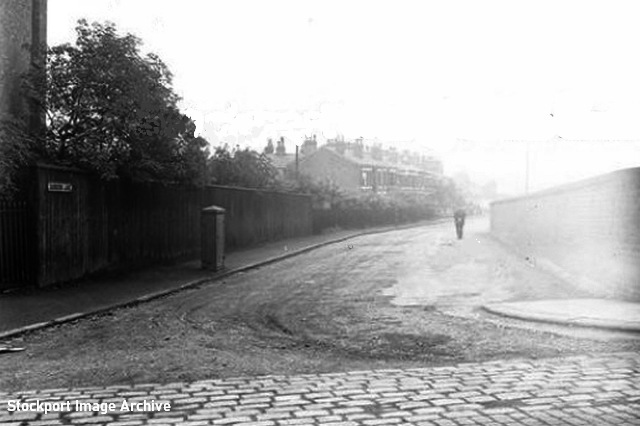
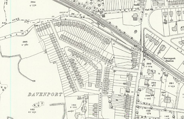
This picture looks down Garner's Lane from Bramhall Lane in the 1920s. Comparison with the 1917 map shows how the new road was close to the corner of the semi-detached pair of houses 'Lyme View', 126 and 128 Bramhall Lane. No. 128, just visible on the left, was bought by the railway company, and occupied by Davenport's Station Master. Further alterations in the 1930s led to the demolition of No.128, leaving its partner no. 126 intact, with a blank wall; the stationmaster had to find another home. This remains the position in 2023 with the addition of the of Oakfield Mews and Poplar Court, built on what was once the garden of no. 128. The numbering of the Winbolt houses, seen in the distance, starts at no.1, which sometimes leads to confusion.
The work in the 1930s saw Bramhall Lane was widened, adding to the railway bridge. The original structure was retained alongside until the 1970s until the 1970s demolished and replaced by the present concrete structure, opening up the the junction further and giving clearance for the overhead wires needed when the line from Stockport to Hazel Grove was electrified.
The Coal Siding
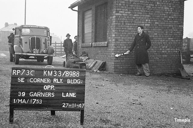
Around 1885, a siding was laid out alongside the running lines north of station for the use by coal merchants who received coal from collieries in railway wagons. The siding, accessed from Garner's Lane by what is now the car park entrance, was in operation until 1964, served by a a train known as 'the shunter' which served coal and other products to stations alomg the line. A visit by the Ordnance Survey Revision Point surveyors in 1947 captured the men of 'Greenwood's Coal' pausing their work unloading coal from the railway wagons, glimpsed on the right edge of the image, and bagging it for delivery to domestic customers.
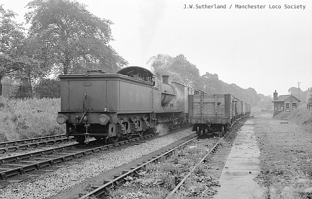
One day in July 1958, the late Wallace Sutherland was on hand to watch the New Mills - Stockport 'shunter' train collect empty coal wagons from Davenport siding. Coal deliveries to the siding ceased in 1964; the track was removed and the building demolished. After some years as a wasteland, the area became the current car park, with its pathway leading down from the bridge.
The Brickworks
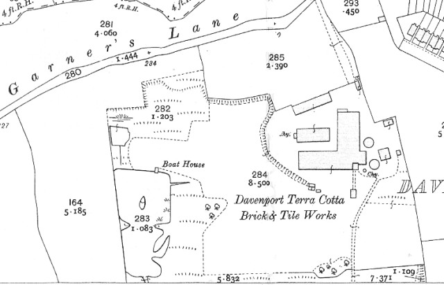
Early residential building occurred on the land formerly owned by the Christy Family, successors to the Davenports, former residents of the nearby large villa 'Highfield'. To the west, on the land owned by the Bamford-Hesketh family, there were different developments. (The 'kink' in the boundary can still be seen today.) The clay subsoil of the area inspired the construction in the 1890s of the short-lived Davenport Terracotta Brick and Tile Works. Nothing remains of the works, but it has left its mark on the land. The works buildings stood near Garners Lane in the area now occupied by Blaven Close; the significant drop in the ground to the west is the result of clay extraction. The works was reached from Garners Lane at the point where this is today a passage for pedestrians.
The 1907 map above is the only one to show the works in any detail, while no photographs have yet come to light. The circular structures are kilns where the clay was baked into bricks. In 1902 it was summoned by the Sanitary Authority for producing excess smoke from their two chimneys, possibly reported by the residents of the large villa 'Highfield' which was close to the works. The fishing lake at the end of the estate is also a result of clay digging, although it has been enlarged.
The works was owned by the brothers Thomas and William Meadows, who operated in their own name a building firm based in Heaton Norris, in addition to a Builders' Merchant with premises adjacent to Stockport Edgeley station, operating as the Davenport Brick and Tile Company. In 1910, the firm ran into financial trouble, executed a Deed of Assignment for the benefit of creditors, a form of bankruptcy. This seems to have seen the end of the brickworks, perhaps it was also running out of raw material.
The works was presumably completely demolished and the ground became waste. But not for long, golfers and anglers had their eyes on it.
The Fishing Pool
The Stockport County Anglers Association was formed in 1893; with the permission of the Sykes bleach works company they fished the Edgeley Reservoir, adjacent to the County football ground until the company was merged into the Bleachers Association, when for some reason they were evicted and a search for a new pool began.
The clay-digging activities of the Brick and Tile Works left a pool at the far end of their site, and the Association rented it from 1907. Later it was purchased jointly by three members, and in 1927 the ownership passed to the Association. One of the three members was Councillor J.T. Barnett, Over the years the pool was enlarged, and facilities provided for members, at one time in an old bus which they were ordered by the Council to paint green. The Association still thrives in 2024, now with housing estates on both side; for safety and security reasons it is not accessible by the public, although there are Open Days from time to time. The association prides itself on its conservation of its area.
The Golf Course
The next phase of the field's existence is well told in the history of the golf club.
Originally conceived in the Stockport district in 1913 by a group who delighted in the name 'The Niblicks'. Their aim was not to form a golf club, but a society, to enable a group of friends to play golf on certain fields. It quickly became apparent that it had indeed become a golf club.Still named Davenport Golf Club, the re-located club has gone from strength to strength. The proposal for a motorway-sized road cutting across Davenport came to nothing, and the land was bought by the Wimpey company who built the leafy Bracadale Drive housing estate with its exotic street names taken from places in the Isle of Skye. The path from 73 Garners Lane to Blaven Close was originally an entrance to the works, and later the entrance to the golf clubhouse.
The Club continued happily until 1966, when road proposals put a threat to its future existence and in 1969 the shareholders agreed to sell the land and purchase Worth Hall Farm in Poynton to enable the construction of an 18 hole course.
The last competition at Garners Lane was played on 29 September 1973 and the members moved to Worth Hall, Poynton in the first week of October.
The Border marker
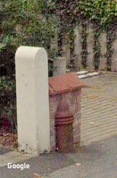
A cast-iron marker stands at the Garners Lane end of the path which once led to the golf course; it marks the former border of Stockport with Cheadle, although the wording has eroded away with time. It now marks the historic border between Davenport and Adswood, although this may no longer used officially.
There are a number of such markers surviving around the town. Some are in this cylindrical form, others have a flat face with the date 1332. For more about these, and their uses, refer to our feature on Kennerley Road.
Later housing
The 1920s and 1930s saw housing development, in a variety of styles, along both sides of the Cheadle part of Garner's Lane, which is in the area known as Adswood,which became of Stockport in 1974. Of interest are nos. 75 and 77, bungalows set back some way from the road. They were built around 1922 by local builder John Bateson.
Intriguingly, a funder of the building work, according to the Land Registry, was Tamejiro Okuno Trevithick (1891-1964), a great-grandson of Richard Trevithick, the famous Cornish engineer who built an early steam railway loco. His father Francis had married in Japan while working as a railway engineer there. Tamejiro lived in Cornwall and Birmingham; why he was buying property in Stockport is a mystery.Beyond no. 77 was an area which had been excavated, perhaps for building materials, sometime between 1922 and 1934. Around the 1960s, this area was bought by Stockport Council, who erected there a small estate of homes, for elderly residents, called Wheatcroft.
Privately-built housing, on both sides of the Lane, mostly of the fashionable 'hipped-roof semi-detached with bay windows' configuration was joined from from the early 1930s by an 800-strong estate of Council Houses, which spread out on to the fields in a network of new roads. A pleasant feature of Garner's Lane as laid out in the 1930s are grass verges each side, planted with hornbeam trees, which have grown to impressive size, without impeding pedestrians. The Ordnance Survey preferred the spelling 'lay' for some reason.
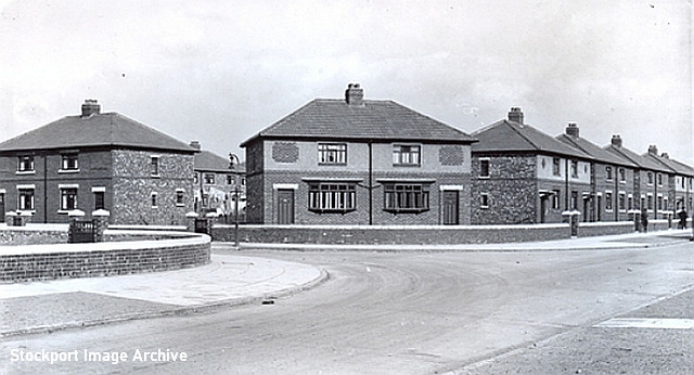
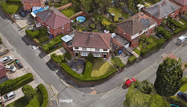
The 193os council houses are also in the hipped roof style, but most lack the bay window, except for the slightly larger ones on the street corners. All the houses are in the same style, but very slightly in the decoration of the frontage. (There are a few examples to be found with their 'front door' on the side.) The view above is dated 1933: the left half of the pair in the centre form 15 Oban Cresent (on the left) and what is today 7 Barnfield Road West (on the right). Below is a 2015 Google map image of the same corner.
The history of Barnfield Road is an curious one: When the farmland was purchased by the Council, the intention was for Barnfield Road to be a through highway connecting Garners Lane with Bramhall Lane, crossing the playing fields. In anticipation of this the estate houses were numbered from the Bramhall Lane end from 100 even onwards on one side and 125 odd on the other. However, the connection of the two roads didn't happen, and the open fields owned by the Christy family remains largely intact. Barnfield Lane West ends abruptly at a fence bordering the fairway of one of the holes of the Golf Course.
Sometime after 1946, the Council houses on Barnfield Road were all re-numbered together in a series starting at 1 from the Garners Lane end, which became Barnfield Road West, while the privately-built houses at the Bramhall Lane end kept their numbers and became Barnfield Road East, the two parts being a significant distance apart by road.
Community Needs
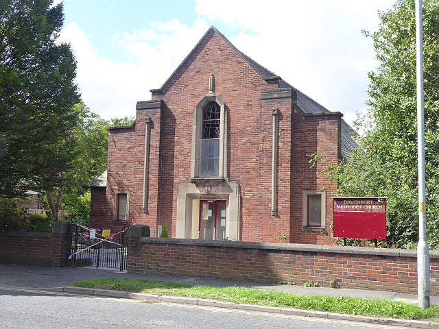
Along with the new houses, the needs of the new community were provided for. Davenport Methodist Church, on Garner's Lane was built in 1937; following the closure of the large Trinity Methodist Church on Bramhall Lane, it has become the only Methodist place of worship in the Davenport and Adswood area.
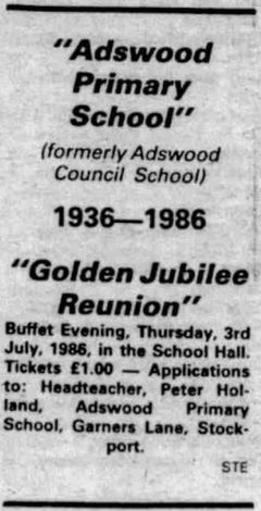
Adswood Council School, opened in 1936, thrives today as Adswood Primary School; the name changed after 1948 when older pupils were transferred to the new secondary schools.
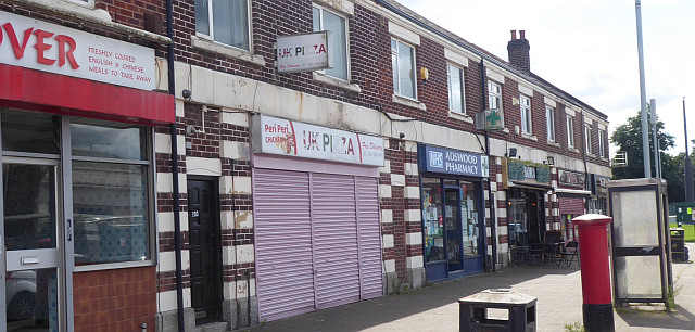
In 1931 Thomas Davies and William Jones Davies purchased from Stockport Corporation a plot of land which had been part of the farmstead, and built a row of six shops which have housed many traders in the intervening years. The 1939 register lists, living above their shops at 201, Benjamin Simpson, supper bar caterer; 205 Frederick B. Sutton, Chemist and druggist; 207 Frank H. Spencer, grocery and provision dealer, 209 George Torkington, Clerk (money lender), and 211 William T. Bridge, Retail dealer, sweets and tobacco. Mr Sutton the chemist, born in London, was the first of a series of chemists at no. 205 which is still a pharmacy in 2023. He retired to Bramhall, where he died in 1982. I wonder what brought him to Adswood?
On the other side of the road, on the junction where Garner's Lane ends and the road ahead becomes Adswood Road, are a range of shops and a health centre, but they are all numbered on Adswood Road and outside our story, except the white-tiled building on the corner, 166 Garners Lane. This was built in 1932 on land purchased from Stockport Corporation for The Stockport Industrial and Equitable Co-Operative Society Limited, as a new branch in what was a new centre.
The Co-Op branch was closed down in 1983 by what was then part of Norwest Pioneers Co-Operative Society . It was subsequently re-opened by 'Best and Boulton' a Hull-based firm whose business was 'Retail sale of other second-hand goods in stores (not incl. antiques)' who stated there for a while. At some time the building has been divided: in 2023 there is the "Snipz 'n' Clips" barber's shop at 166A and and at 166 'Cali Wines' who offer 'A Free Off Licence and Groceries'.
The area once also sported its own pub, the Wembley Hotel, in the large 'roadhouse' style , built at 276 Adswood Road in 1934 for Wilson's Brewery. It was closed and demolished in 2002, replaced by housing - 'Wembley Close'.
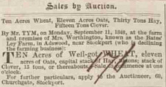
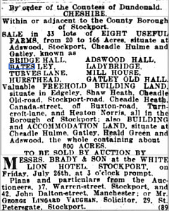
Bates Ley Farm
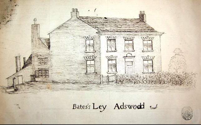
Bates Ley farmhouse, which stood at the end of Garner's Lane at the junction with Adswood Lane, was swept away in the house-building boom of the 1930s. It had a long history, with a series of tenants, but facts are hard to find. We do have a idea what it looked like in the 1800s, thanks to nineteenth-century historian John Owen, whose many manuscripts are preserved in Manchester Central Library. The farmhouse was very similar to many in the area, built in local brick with a central doorway.
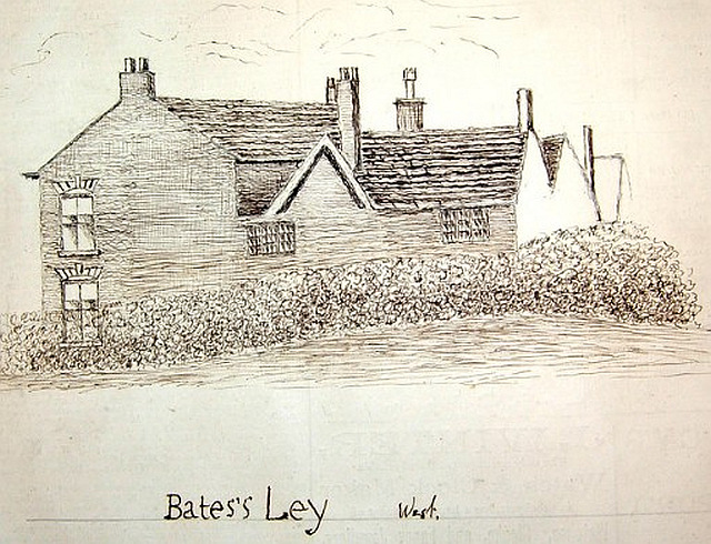
At the rear was what appears to be a much older farmhouse, with smaller windows, although the drawing seems a little odd.
This detail from a modern map with field and ownership shows the extent of the Bates Ley farm in 1841. The area is that within the red line showing the boundary of Bramhall township, less the area coloured red which was owned by the Davenports, except the area coloured red. It seems that Bate Ley had been Davenport-owned, but passed at some stage to the Bamford-Hesketh who were related to the family. The farmhouse, near the top left of the extract seems to have straggled the border. Over time, the area of the farm, said in 1831 to comprise '48 Cheshire acres and upwards' was reduced, notably by the loss of the four fields on the east side by clay extraction and associated brickworks.
This plan from 1916 shows that there were several buildings comprising the farmstead, and an orchard. Garner's Lane itself seems to end amongst them.
The farmer at that time, successor to Newton Unsworth who returned to his family farm in Carrington, was Thomas Lewis Woodall (born 1855 in Bowdon, Cheshire) , assisted by his second son, Samuel Venables Woodall. The family had moved to Bates Ley in the 1890s from Abney Hall Farm in Cheadle, although an 1899 register shows them still spending part of the year at Abney. The family history of the Woodalls is listed in the left-hand column.
The Community Centre
After the death of Thomas Lewis Woodall, the Corporation offered for sale the remaining buildings, but in the end it remained public land, classified as 'greenspace' , partly occupied in 2023 by the Adswood Community Centre which seems to have been built around 1948. I'd like to hear more about the history of this building.
This marks the end of Garner's Lane, as Adswood Road comes in from the right and continues towards Cheadle.
Appendix: Rostrevor Road
Rostrevor is a picturesque village in Northern Ireland, at
the southern entrance to the Mourne mountains and along the
shores of Carlingford Lough. In 1612 Sir Edward Trevor
married Rose Ussher, daughter of the Archbishop of Armagh
and it is said that he named the village after his new young
wife. It must have been a favourite holday destination for
the Pennington family of Stockport, as when they built
a home for themselves adjacent to Garners Lane they named it
'Rostrevor'. Or maybe they just liked the name, or
maybe Rostrevor Road had already been named by the Council
for the road which leads from Adswood Road, past a
(long-lost house called Holly Cottage) to Garners Lane and
beyond. Peter Pennington was born at 8 Lancashire Hill in Heaton Chapel, the Lancashire part of Stockport, in 1862, to James Pennington, a brush maker. and his wife Ann, a shopkeeper. Peter trained as a joiner and was able to to start a building business, first at 10 Halesden Road, Heaton Chapel, and by the 1920s in 60 Rostrevor Road,
Pennington's self-built house, described as a 'semi-bungalow' was built in the 1920s, at a time when many new houses for Stockport Corporation were covering the area. It's likely that the building firm of Pennington Bros. were amongst those engaged in this project. Peter died in 1930, but the business continued. The house was sold by his widow in 1934.
The next resident was Charles Barnet Victor Walker, who adapted it as a live-in surgery for his General Practice. A graduate of Manchester Medical School, he is recorded there in the 1939 National Register, having re-located from 18 Longshut Lane West. His wife Elise acted as secretary.
In 1950 His father, also called Charles Barnet Victor Walker, died, and 60 Rostrevor Road was offered at auction, with a comment that it could be used by a dentist or similar profession.
It's not clear who, if anyone, lived in the house after 1950, but in 1974 began a sequence of planning permission request to demolish it and build flats, until permission was final given to demolish the building and replace it with a 'two storey residential development comprising of 8 two bedroom apartments' was granted in May 2004. The result is named 'Rostrevor House', a block of flats which stands at 60 Rostrevor Road in 2024 is a modern building in a style matching the surrounding houses.
Rostrevor Road itself (marked above on a 1938 map, showing the original route on the north part) has some eccentricities. Starting from Adswood Road, car drivers find their route blocked by housing, with only a footpath continuing to Garner's Lane. Once there, it crosses to the other side, without change of name, and has been extended in later years with over 100 modern houses.
For the Corporation estates, when faced with naming the streets, the Councillors chose two 'themes' . Names beginning with 'Ros' (Roslyn Road, Ross Avenue, Rostherne Road) and place names apparently randomly-chosen places around the UK - Northcombe, Ashburton, Oban, Eccleston, Otley, Melrose, etc.
Written by Charlie Hulme March 2024.
Comments welcome: davenport@nwrail.org.uk