Davenport Junction and the 'Khyber Pass'
Compiled by Charlie Hulme
Davenport Station home | Index to History pages
This is an enhanced version of a feature first published in 2006.
Until the 1960s, trains departing Davenport towards Manchester passed rather more railway installations than can be seen from a train today. Removal of a bridge and house-building have obliterated much of the railway infrastructure. Here we explore the history of the area and look for evidence of what was there.
The railway dealt principally with goods traffic. A regular passenger service lasted just a few years; in the twentieth century the occasional diversion, excursion or enthusiasts' special passed that way.
By the 1960s, railway freight traffic was on the decline, and it was decided to concentrate the remaining trains on the parallel 'Midland' route through Chinley, avoiding the route through Whaley Bridge and Davenport which had always been very difficult for freight trains, thanks to its very steep gradients which meant that many freight trains had to be 'banked' - pushed by another locomotive to get them up the hills.
In January 1965, the goods depots along the line closed, and goods trains ceased to run on the Buxton line, although for a while afterwards part of the 'Khyber' line was retained as a siding for coal wagons serving the Co-operative Society premises which lay between this line and the curve towards Stockport.
Coal was also the purpose of the siding which once occupied the land now used as Davenport station car park.
Rationalisation in the 1900s left only existing line between Davenport and the junction with the main Crewe line at Edgeley.
The Buxton Line:
a brief history
The railway from Stockport to Buxton via Davenport was opened in two phases. The line from a junction with the London and North Western Railway (LNWR) Manchester to Crewe line to Whaley Bridge was built by the nominally-independent Stockport, Disley and Whaley Bridge railway, opened in 1857. A leading supporter of the project was Thomas Legh of Lyme Park; sadly he died not long before the line opened.
Colonel Davenport of Bramhall Hall also supported the line, as he hoped to raise money with housing development in what was, at the time farmland. He agreed to the line passing through the edge of his estate on the understanding that a station should be provided at the Bramhall Lane bridge.
However, when the line opened, the only stations were at Hazel Grove, Disley, New Mills and Whaley Bridge. The Colonel protested, and in 1858 a small station was opened. It was named 'Davenport' which also became the name of the settlement which arose, quite slowly at first, around the station. Passengers failed to materialise, except a few souls making a country walk to Bramall Hall. The station closed again after a few months, opening again in 1863 by which time a few houses had been built.
Soon after the opening of the first section, building began on an extension to Buxton, which opened in 1863.
The station as we know it dates from the 1880s, some time after the Davenports had sold the Hall and moved away from the area. The 'Khyber' line was added to give the LNWR a route for goods trains from the Midlands to the port Liverpool, to compete with the Midland Railway company whose trains ran via Stockport Tiviot Dale station.
In 1923 the two companies were merged into the London Midland and Scottish Railway, and the LNWR route, with its very steep gradients on the Buxton line, became largely redundant as a route to Liverpool, but some trains continued to go that way until 1964; changes can take time on the railway.
Buxton to Liverpool, 1880s
Reproduced with permission from The Mancunian, journal of the Manchester Locomotive Society, issue 121, 1984.
The passenger service over the 'Khyber' line which began in 1884 consisted of one train each way daily (except Sundays) between Buxton and Liverpool, leaving Buxton at 8.35am and returning from Lime Street at 4.25pm. Intermediate stops were at Broadheath, Warrington (Arpley) and Edge Hill only and the 56¼ mile journey took 80 minutes.
The westbound train also stopped at Warrington (Bank Quay-Low Level) to connect with the 9.57am from the High Level station to Carlisle and Scotland, whilst initially the train from Liverpool did not call at Edge Hill. [The route onwards from Northenden to Liverpool followed the line through Lymm which today forms part of the Trans-Pennine Trail.]
The service was very similar by August 1887 but in July 1893, when the trains were described in Bradshaw as "Buxton Express", the 8.50am from Buxton was taking
85 minutes to reach Liverpool, with the same stops. The return service from Lime Street was now at 4.20pm, and with stops at Edge Hill, Bank Quay, Arpley and Broadheath,
it did not arrive in Buxton until 6.00pm, a journey time of 100 minutes, or
25% longer than when the train was first introduced.
In 1893,the fares between Buxton and Liverpool were:—
lst Class 8s.0d single,
15/2d return.
2nd Class 6s.0d single 10s.8d return.
3rd Class 4s.5d single
8s.3d return
The service did not appear in the November 1893 "Bradshaw" timetable so the trains must have been withdrawn sometime between July and November 1893, possibly at the end
of the summer service.
So far as is known, there were never any further scheduled passenger trains over this line.
[A newspaper of June 1889 states that a fast service from Buxton to Liverpool taking an hour and twenty minutes, was to start in July. so perhaps the service was sporadic or ran in summer only for a while.]
The Bomb Plot
An action which could have had much worse results, occurred in 1913, a time of much unrest in the country.
Strikes were frequent - in April 1913 the carters of Stockport were striking - and the 'Suffragettes' were engaged their destructive protests in the hope of achieving votes for women. Railway stations and trains were frequent targets, although supposedly with care taken to avoid injuries to staff.
The item below is from The Manchester Guardian of 5 April 1913, page 10.
EMPTY RAILWAY COACH BLOWN UP
--
OUTRAGE NEAR STOCKPORT
The police have failed to discover any clue likely to lead to an explosion which wrecked a railway carriage at Adswood, Stockport, late on Thursday night.
Suffragettes are suspected, but nothing was left behind to identify the women militants with the outrage.
An empty Buxton train of seventeen coaches was left on the line between Davenport and Cheadle, which passes over the main London and North-Western Railway Manchester to London line.
Shortly before eleven o'clock the driver of a train on the lower level heard an explosion, and a piece of wood struck his engine. He told the railway officials at Stockport that he thought a gas cylinder of a railway carriage on the upper line had blown up.
An investigation by Inspector Williams showed that a compartment in the rear coach of the empty Buxton train had been wrecked by an explosion. The doors had been blown off, and one was discovered thirty yards away on the embankment of the Crewe line. The windows and sides of the carriage were smashed and other parts of the carriage greatly damaged. Pieces of canister were found sticking in the roof of the carriage.
Apparently a canister had been exploded under one of the seats, whilst paraffin had been poured on the floor of the compartment and over the seats, and a quantity of fire lighters which had been steeped in oil and resin was found on one of the seats.
The explosion however, did not cause an outbreak of fire. A tin which had contained paraffin was found in a field close by. The railway at this point is near the Adswood Road, and is easily reached by anyone climbing the railings.
The police do not connect the strikers in the town with the outrage. [There was a strike of carters in progress at the time.]
Manchester - Buxton trains never had seventeen coaches; it's likely that the redundant second line was being used as a siding to store spare rolling stock.
Asleep in the Box
The signalman at a place away from a station, such as Davenport Junction led a lonely life. No doubt he welcomed the unofficial visits by Mr Sutherland and his camera. Shifts were long, and occasionally things went astray; although rarely with any safety risk due to the safety measures built in to the signalling equipment.
Trevor Moseley recalls one such day:
One afternoon on my way home from work we were brought to a stand by the signal at Edgeley Junction which controlled the junction on to the Buxton The signalman advised our driver that he was unable to raise the signalman at Davenport Junction and we were to proceed at caution and examine the line.
We crawled up to the Davenport Junction 'home' signal and our driver left the cab and gingerly approached the box and climbed the steps. By then a good number of passengers were hanging out of the window following the proceedings.
The driver banged on the door and seconds later the relief signalman came to the door, awakened from his slumbers!
Signalbox mystery
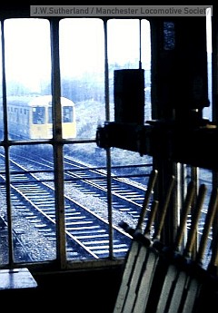
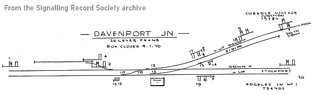
Davenport Junction signalbox as seen in these images cannot date from the opening of the line, as it is built in the architectural style first used by the London and North Western in 1904, with larger windows than their (much more common) previous version. Why and when an original 1883 box was replaced is unknown at present.
Photographs and maps the period is very scarce.
The LNWR were late in installing the 'block system' on branch lines, a photograph from the 1870s shows levers on the platform at Davenport station, a sign that the less-safe 'time interval' system was still in use, perhaps with a simple telegraph.
However, a signal box at the Junction is shown on an 1898 map. There is evidence that the signalbox was altered some time before 1896 to control the coal siding.
The most likely explanation that the box was damaged somehow - fire, subsidence, a derailment perhaps - sometime afer 1904, and had to be repaired. The brickwork in the base shows signs of repair.
Gallery
On the Khyber
The road bridge
The Co-op siding
Davenport coal siding
Turning a loco (1)
Turning a loco (2)
Sources and thanks
The images by the late J.W. Sutherland, a Davenport resident, are part of his collection generously gifted by his widow, Mrs Tril Sutherland, and are now held by the Manchester Locomotive Society. Along with many more, they can be viewed on the Society website. Mr Sutherland's pictures and writings are a unique record of Davenport's railway history.
Thanks also to John Wadsworth for the 1979 photograph.
I owe a debt to Trevor Moseley and the late Graham Neve, railwaymen and founders of the Hazel Grove Model Railway Society for their help and inspiration over many years. In the bygone days of the 1960s it was possible to be invited into signalboxes, and even try pulling the levers.
More recently, the members of the Manchester Locomotive Society have welcomed me into their team, and have helped me in many ways.
References
For essential reading on the history of this line and the Buxton line in general, refer to the two books published by Gregory Fox as no. 50 in his 'Foxline' 'Scenes from the Past' series.
Part 1: Stockport, Davenport and Hazel Grove to Disley, New Mills Newtown and Whaley Bridge. By Gregory Fox.
Part two: The Buxton Extension. By Gregory Fox and J.M.Bentley.
old-maps.co.uk
Timepix ordnance survey images
For signalbox information, I have consulted:
Records from the archive of the Signalling Record Society
Richard Foster:
A pictorial record of L.N.W.R. signalling . Oxford Publishing Company, 1982
Signalling Study Group The Signal Box: A Pictorial History and Guide to Designs. Oxford Publishing Company, 1986.
For an introduction to signalling, see British Railway Signalling by G.M. Kichenside & Alan Williams which is available on the second-hand market.
For an insight into Suffragette activities see: Simon Webb. The Suffragette Bombers: Britain's Forgotten Terrorists. Pen and Sword History, 2019.
For the difference between a suffragette and a suffragist, see our feature on Hannah Winbolt.
Comments welcome at info@davenportstation.org.uk
Due to the steep gradient either side of the main line bridge, the new line became known to local railwaymen as 'The Khyber' after the mountain pass between Pakistan and Afghanistan, (British forces built a highway and marched through the Khyber Pass to launch an offensive against the Afghans in the Second Afghan War (1878-79) and the area was very much in the news during Victoria's reign.)
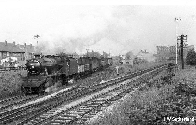
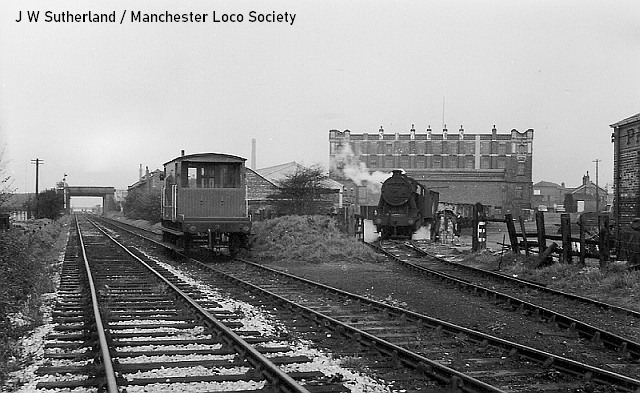
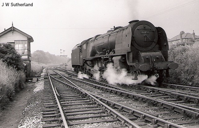
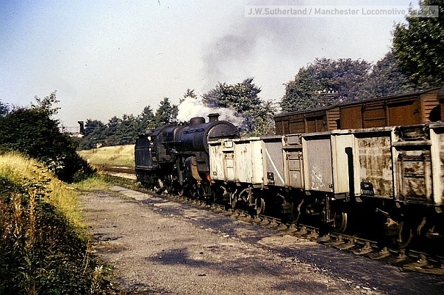
The view from the signalbox on 14 June 1958, by Mr Sutherland. Buxton-based '8F' 2-8-0 48166 negotiates the junction with a Liverpool Edge Hill - Buxton goods. In the distance, another 8F on an Edgeley - Buxton local goods is shunting the Co-op siding. The landmark Co-op warehouse can be seen in the distance. The train will cross to the Buxton-bound track beyond the junction.
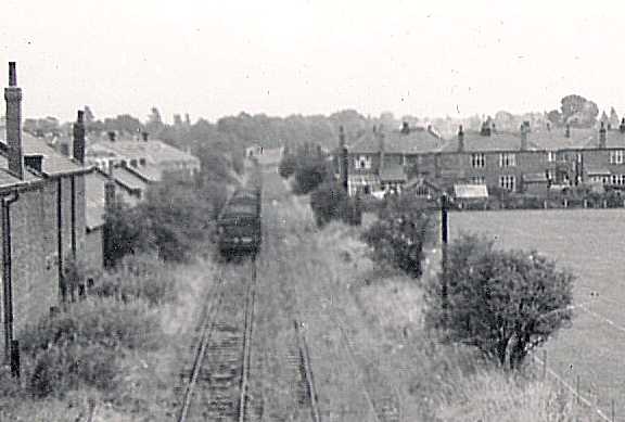
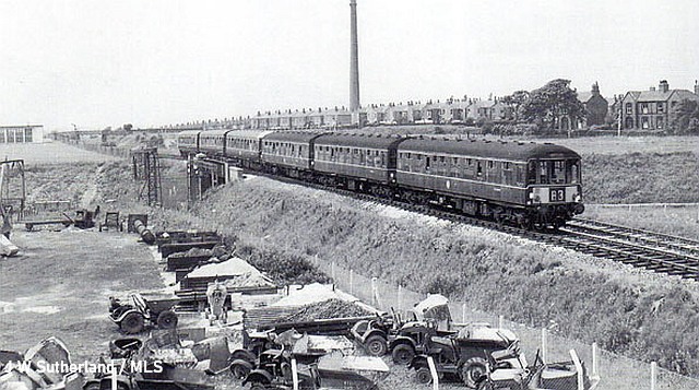
An excursion from the Buxton line begins the climb of the Khyber line, c. 1966.
The line was built as double-track, but early in its life, after the demise of passenger traffic, it was worked as a two-way single-line, with the other track acting as a siding. The train in the picture above, taken in September 1962, is standing in the siding, possibly waiting for a 'path' on the line towards Buxton. The Adswood Road bridge is in the distance.
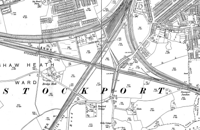
This Ordnance Survey map from 1907 shows the area before twentieth-century housing developments. The bridge from which my ancient picture was taken is near the centre of the extract; the Stockport - Crewe line runs from top to bottom and the Northenden line curves round to the top left. There is no trace of this bridge today, the road junction area is at a lower level. The map also shows 'Adswood Old Road', a fragment of the pre-railway course of the road, with a row of cottages, apparently known as 'Railway View'.
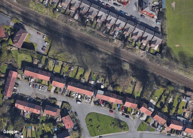
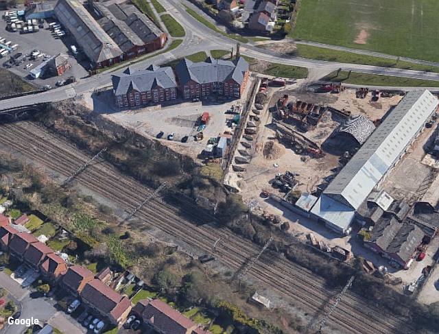
The site of the former junction with the Buxton line is not visible today from a passing train, but on a map or aerial picture (see above) it can clearly be seen as the former railway boundary follows the end of the gardens of the houses in Aintree Grove built in the 1930s. A thin wedge of land has been left to nature - perhaps an informal park for the residents - as far as the end of the modern Newsham Road. The apartment block in the top left corner of the image is built across the former track bed.
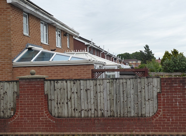
This picture was taken in 2021, from as near to our 1966
picture as can now be achieved. The road bridge (with its
associated embankments) no longer exists, so it was
necessary to stand just above the original level of the
railway track; the path of the line lies under these
houses and their gardens in Newsham Road.
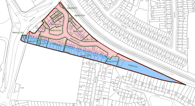
This Land Registry plan shows the path of the line east of Adswood Road; the pink area is the former Co-op site and the blue area is the land purchased from Railtrack by the developers of Newsham Road in 1995. The playing field remains a well-used facility. The area was historically part of Slain farm; the pink area was leased in 1905 from the farmer Charles Alldis Brady by Joseph and William Briscoe, who were paving contractors.
Soon afterwards the land was taken over by Stockport Industrial and Equitable Co-operative Society as a base for their operations. Two sidings for their use had been installed by 1910, and by 1922 the houses on Adswood Old Road has been demolished and the large bakery and warehouse building constructed on the site, as well as further sidings. By 1934 further buildings has been erected on the other side of Adswood Road, some of which still stand in 2021 as the Creamline Dairy, while the original site was cleared and the warehouse building demolished in the Spring of 1986, following merger of the Stockport Co-op into a larger group.
The Co-op sidings may have been used for receipt of various materials, but by the 1960s were principally for the receipt of coal, some of which would used by the on-site bakery and other operations, while the rest would be transferred to horse-drawn carts for delivery to Co-op customers, around the town. The horses were stabled on-site.
The construction of the line, completed in 1883, required a major change to Adswood and Reservoir Roads to bridge the line, which itself was climbing to a bridge over the Manchester - Crewe route. The map shows the embankments needed to achieve this; Adswood Road was a narrow lane at this time, It was reconstructed in 1928, and again in the 1980s after the closure of the 'Khyber' line. In 1988 the bridge was removed and the road lowered.
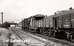
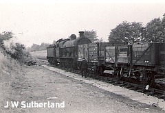
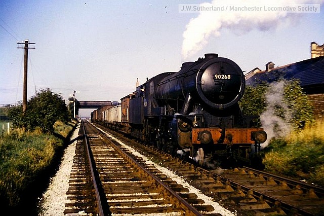
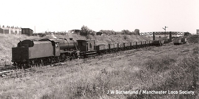
On 1 May 1965 Mr Sutherland photographed the Co-op siding being serviced by '8F' locomotive 48182 on the working that railwaymen called 'The Divi' inspired by the 'dividend' that members of the Society were entitled to on their purchases. The guard's van has been left behind while the crew extract empty coal wagons and deposit full ones. All other freight traffic on the Buxton branch had ceased the previous year. The Adswood Road bridge is beyond.
This aerial vew from 2021 shows the straight path of the line from Newsham Road (at the top), then the site of the former bridge carrying Adswood Road over the line, and on a straight course through the site of newly-built 'Bakery Court' flats, along the boundary with the industrial premises to the remains of the bridge over the Crewe line. (The abutments of this bridge are a remaining relic of the line, best seen from a passing train). Around 1960 the bridge was raised to clear the overhead electric wiring which was being installed, slightly increasing the gradient 'over the Khyber'. Beyond the bridge any trace of the trackbed disappears under the houses on 'Pintail Road', part of a small modern estate with streets named after species of birds.
Further on, the line crossed the open fields of Bridge Hall farm, which today accommodates Bridge Hall Primary School, serving the people of the Bridge Hall housing estate which replaced the farm after World War II. The line passed under a footbridge adjacent to the similar bridge over the nearby Northenden line which remains in frequent use.
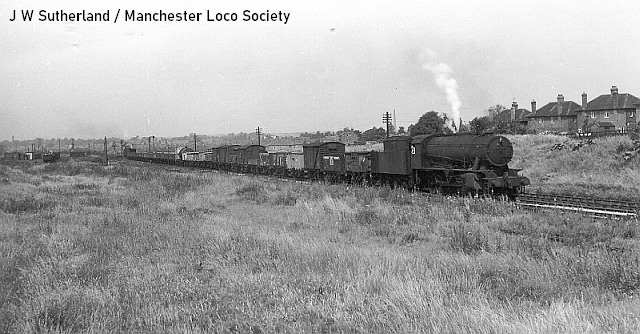
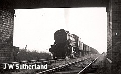
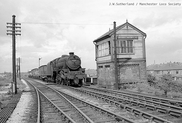
On 25 June 1960 the Birkenhead - Buxton goods, headed by loco 90369 has negotiated Cheadle Village Junction ...
... and heads towards Davenport. A 'banker' loco has been attached to the rear to help the train on up the steep hills ahead. On the Cheadle side of the footbridge there was a set of sidings as seen in the picture above; after the closure of the line the area was transformed back into a field - with its historic name Edgeley Field - as a community resource; there is now no trace at all of the railway on this section, the level of the ground has been changed.
The line from Davenport Junction met the Northenden line at a point near the former Cheadle Well pumping station where there were more sidings. The junction was sited in the area of the modern-day Police Station. The name 'Cheadle Village Junction' remains in use by the railway in 2021, as it is the point where the line from Stockport on to Northenden becomes single-track, a short-sighted decision, in view of later increases in traffic, freight trains, and passenger trains diverted to the line to make room for Metrolink - and now the the planned new station at Cheadle. Anthony Hewitt has kindly written an explanation for us:
The M63 Motorway, now part of the M60, had been extended to Stockport and opened in 1975. The Stockport - Northenden line crosses the motorway at Junction 11, known locally as Roscoes Roundabout.
Two bridges had to be built because the railway crosses the actual
roundabout, and the MoT had demanded the the line be singled to reduce the cost of construction for M63 Junction 11. British Rail would not have objected too strongly and would have seized the opportunity for the M63 construction project to pay the costs associated with closure of Cheadle Village Junction Signalbox. The engineering and bridge re-construction works for singling of the line would have been categorised as preparatory works by the M63 project management and the Ministry of Transport.
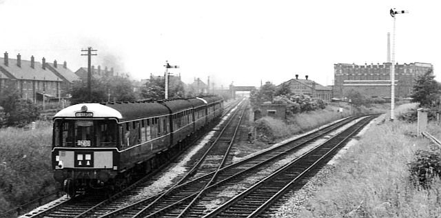
Passenger trains on the line were scarce, but on a few occasions it was used as a diversionary route for Buxton line trains during engineering work. The image above from June 1963 shows a Sunday Buxton - Manchester (heading away from the camera) alongside the yard of the Johnson Machinery works, crossing the bridge over the Crewe line and passing Bridge Hall school. Johnson's manufactured small dump trucks, some of which are seen in the foreground. The train is formed of two three-car Birmingham Carriage and Wagon Company diesel units which served the Buxton line from 1957 until the late 1980s; it will reverse at Cheadle Village Junction to reach Stockport station via the Northenden line and Edgeley Junction.
Cheadle Village Junction, 1961, with loco 45182 on a goods train. The signalbox is in the pre-1904 London and North Western Railway style.
Davenport Junction signalbox
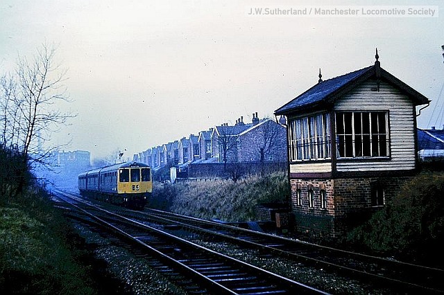
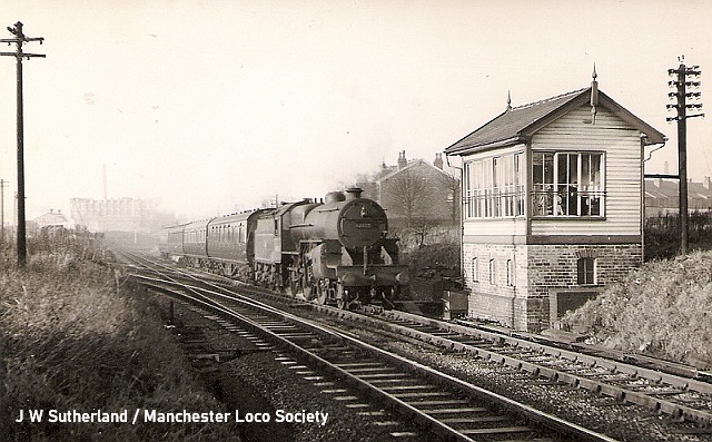
A rare colour picture of the signalbox in December 1969 just before it closed permanently from 4 January 1970 and was promptly demolished. A Manchester - Buxton train is approaching.
The view of the signalbox from the other end; unusually it didn't have the identifying name-board or letters normally seen on signal boxes.
The line completed a 'triangle' with the Buxton and Crewe line, and at times, especially after the turntable at Manchester London Road (today's Piccadilly) was removed to construct a new signalbox, this was used to turn locos which had arrived on trains from London and were too long for other available turntables.
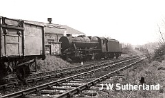
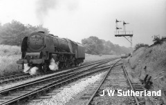
The picture above, from 21 June 1958, shows 'Coronation Pacific' 46252 City of Leicester in the process of turning. It has travelled 'tender-first' along the main line from Manchester, arriving on the track in the foreground, travelled to a point beyond the cross-over points seen in the distance, and returned to continue on to the 'Khyber' line. It will reverse again at Cheadle Village Junction and travel (tender-first again) back to Manchester ready to pull a southbound train.
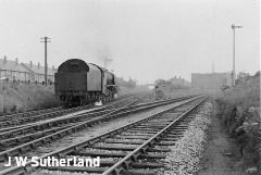
The driver of any train using the single-line had to be in possession of a metal 'token' issued by the signalman. Electrical systems ensured that only one token could be in use at one time; the picture captures the signalman returning to his box by means of the boardwalk provided for the purpose after handing the token to the fireman.
When not in use for shunting the Co-Op siding the other line could be used to hold freight trains waiting for a path on the line towards Buxton.
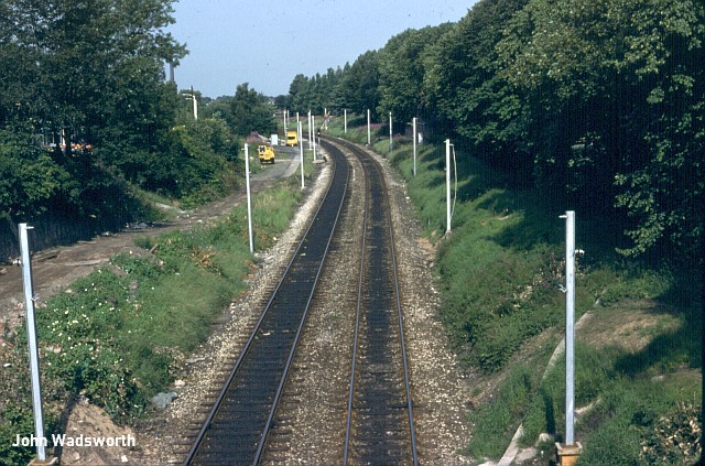
The crossover was retained when the signalbox was abolished, with the status of a hand-operated 'Emergency Crossover' provided with a 'ground frame'. This took the in the form of a small hut, a track diagram, a telephone link to the signalbox at Edgeley Junction, and three levers to work the points and signals. If there was any blockage of the line at Stockport, trains - by this time diesel railcars with a cab at either end - could be turned round and provide a Davenport - Buxton service.
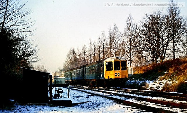
The picture above, taken on New Year's Eve 1979, shows a train from Manchester passing the crossover. It was rarely used, and was never equipped with overhead wires for use by electric trains. It was removed some time in the 1980s; on occasions since, trains have occasionally turned back in Davenport station and travelled 'wrong line' to a crossover at Hazel Grove, but this appears to have been prohibited in the 2000s, resulting in more replacement bus travel for Davenport and Woodsmoor passengers.
The coal siding
The 1880s saw further significant changes in Davenport's railway scene. The London and North Western Railway purchased from Blanche Christy of 'Highfield House', Bramhall Lane, an area of land south of the Stockport - Buxton line between Davenport station and Davenport Junction. The main aim of this was to divert Garner's Lane to join Bramhall Lane at the station, removing the need for a level crossing, but also made space for a siding for the use of local coal merchants. The booking office at road level was also built at this time, and a cottage that had been provided for the crossing-keeper was demolished.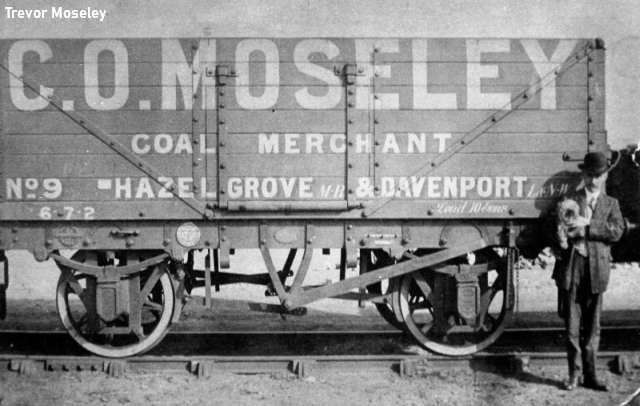
Charles Oswald Moseley poses with his latest coal wagon (and dog), circa 1911.
Wagons of coal, consigned to individual merchants, would be shunted into the siding by the local 'pick-up goods' train as required, and emptied wagons collected. The points to the siding were controlled by Davenport Junction signalbox; the layout only allowed trains travelling towards Stockport to serve the siding. A short 'neck' line served to trap any errant wagons that threatened to foul the main line. For many years, coal wagons were privately owned, either by collieries or by individual merchants. Merchants unloaded the wagons and bagged the coal, weighing hundredweight sacks for distribution. Heavy work, even though the door of the wagon could be lowered,
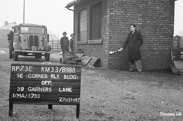
Visit by Ordnance Survey Revision Point team, 1947,
The 'shunter' local goods train from New Mills (Newtown) has left the rest of its train (possibly containing products from Bowaters in Disley) on the main line and entered the siding to either collect empty wagons or deposit full ones. The siding could only be reached from the 'down' Stockport-bound line, so loaded wagons for Davenport would travel to New Mills and back.
The 1948 nationalisation of the railways ended the use of 'private owner' wagons, and railway-owned wagons were used, including, for a number of years more, the former private owner ones which British Railways had been compelled to purchase. This arrangement - with more modern wagons - carried on at Davenport until 1964, by which time domestic coal sales had reduced, and it was no longer considered economic for the railways to serve small sidings. The brick cabin provided for the merchants was demolished, the rails were sent for scrap and the land became waste.
The view from the Bramhall Lane bridge in 1979: supports in place for the electrification to Hazel Grove.
In the 1980s the area was turned into a small car park. A new path was created opposite the station for car park users, and the railway management took the opportunity to include a secure area to store equipment and materials.
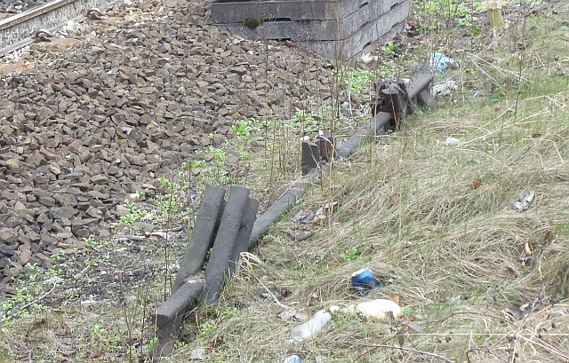
One small reminder of the coal siding remains in place in 2021: the buffer stops at the end of the siding were deeply embedded into the ground, and the 'scrappers' simply cut them off. One side can still be seen; the other side is now buried.
Compiled by Charlie Hulme, July 2021. Updated September 2024