Davenport Station home | Index to History pages
Catching the Train
With best intentions, the railway companies and transport authorities have created a complex array of different fares which can baffle even self-style experts (like ourselves!) at times, although the station staff are always willing to advise. The information here is unofficial cannot be guaranteed, and the fares quoted apply only in March 2019.
Times
The weekday service to Buxton has been increased since May 2018, with two trains per hour for much of the day, and one per hour evenings and Sundays.The Northern website has times and timetables.
The reliability of the service seems to have settled down since in 2019.
Don't pay too much
(Note: at the time of writing the self-service ticket machines cannot issue tickets from stations other than the location of the machine: you'll need to buy those at the ticket office or on the train.)
An important point to note is that the last station in the Greater Manchester area is Middlewood. If you hold a Concession Card ('bus pass') then after 9.30am weekdays and all day at weekends you only need to buy a return ticket valid from Middlewood to Whaley Bridge.
If you commute with a weekly, monthly or annual System One Traincard or County Card, by a special agreement you only need a ticket from New Mills to Whaley Bridge. (This does not apply to Season Tickets with named stations.)
All such cards are valid seven days a week.
For those without such a ticket, a Day Return ticket is required. Before 08:59 on weekdays, these are more more expensive - £9.20 versus £6.90.
Travel in twos
There is a ticket called a 'Duo' which allows two people to travel together for the price of one and a half the off-peak fare, but this is subject to additional restriction that you cannot travel between 16:00 and 18:30 Monday - Friday, and cannot be bought at weekends in December.
However, if you travel together off-peak regularly, we recommend the Two Together Railcard which costs £30 per year (£15 each) and one-third off all fares - a bigger discount than the Duo and is valid from 09:00 on weekdays and all day at weekends, with no evening restrictions. Use it for just one long trip in the year, e.g. to London, and you have saved the cost of the card. You can even use it in First Class where available.
There are other railcards for solo travellers of various ages: details are on the Railcard website. Note that unlike the Greater Manchester concession card which now requires you to be of national pension age, the qualifying age for the Senior Railcard is still 60.
Comments are very welcome:
info@davenportstation.org.uk
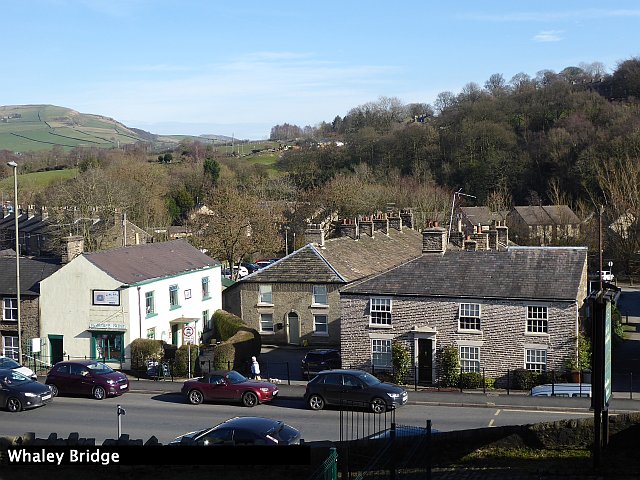
24 minutes on any Buxton-bound train will take you to the centre of Whaley Bridge, a small High Peak town well worth exploring, both for its countryside and its history. Our March 2019 station picture display shows some of the attractions. Whaley Bridge, which originally grew up around its bridge over the River Goyt.
Link to a map on Open Street Map
The industrial heritage of the area can be traced by a walk along the towpath of the Peak Forest Canal and by walking the paths on the inclines of its former connecting railway. The area around Toddbrook Reservoir, which supplies the canal with water, also offers a pleasant walk.
Our five images are those used in the Davenport waiting room display in 2019. Above, the view from the station area across the former Manchester - Buxton turnpike road. The houses date from the early nineteenth century; set back from the road is the former Navigation Inn. The small town centre, including toilets and refreshments, is immediately outside the station on the Buxton side if needed.
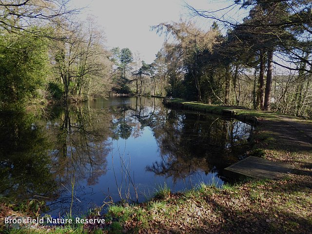
From the station, cross the footbridge to the Manchester-bound side and walk up the hill (the first version of the Turnpike road cane this way, and over the hills to Disley). Take the first turn on the left (Orchard Road) and after passing a building on the left which is a former Baptist chapel, take the path which forks down to the left to meet Reservoir Road, and head uphill to find the green gate leading to Brookfield Nature reserve. The pond here was created as a reserve of water for the Bingswood Printworks down by the canal, and the bench provides is a good place for a peaceful rest.
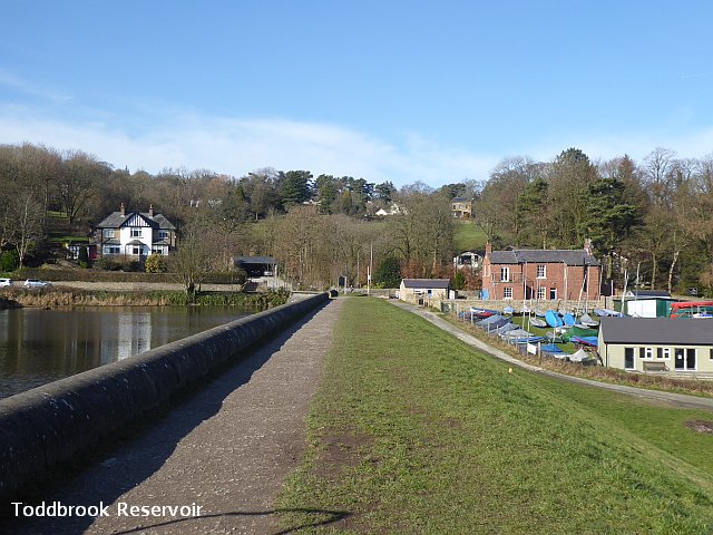
Continue up Reservoir Road to the little bridge on the left which leads to the dam of the Toddbrook reservoir, one of two which supply water to the Peak Forest canal, and beyond to the Macclesfield canal. At weekends, a boat club operates here. (there is a pleasant extra waterside stroll available if you cross the bridge a few yards along Reservoir Road. Unfortunately, this path, built for waterways staff, currently has no exit at the far end.)
Our route continues across the dam, turning sharp left on to a path leading down into the Memorial Park, created in 1920 as a memorial to the 108 villagers killed in the war; it has recently has some very useful improvements to the footpaths. Head down towards the river bridge in the far corner, but instead of crossing it, take the signed Riverside Path, noting the Point where the Randal Carr Brook joins the Goyt. Continue past a row of houses to emerge on busy Macclesfield Road, turning left.
Make the traffic lights to cross Macclesfield Road and then Buxton Road, briefly turn right, the left on to New Road, a rather rough unadopted road which leads to a sheltered housing development, named Cromford Court. Railway from Whaley Bridge to Cromford had a goods depot here, which operated until 1965.
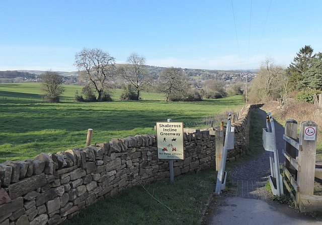
Follow the road to find the 'Shallcross Incline Greenway', which occupies the incline up which Cromford-bound goods wagons were hauled up to the higher level by a cable hauled by a steam engine at the top - one of several such inclines or 'inclined planes' on the line. This one, along with the line beyond as far as Hurdlow, south of Buxton, was abandoned in 1892. A walk up the recently re-opened path , on a steady 1 in 10 gradient, is good exercise and leads to a good the view across the valley, seen above. On the horizon is Black Hill (1339 feet above sea level), the slopes of which can be seen fro the other side by looking along the line from the Railway Bridge at Davenport.
There is a interesting information board at this point. You can descend the same way, or turn right for an extended walk back via Taxal. Near here there stood until 1969 a large house, Shallcross Manor; the Shallcross family also had a town house in Stockport, now preserved as Staircase House.
Our route goes back down the incline, and follows the railway route, tunnelling under Chapel Road, and running behind houses and the Cock Inn to a point where walkers have to temporarily return to the road. There was a railway junction here: the line to the canal passed under a low bridge (too low for locomotives) carrying the current line from Whaley Bridge towards Buxton. A line which ran straight ahead connected with the main line at Whaley Bridge station. Take the small path down to the road, turn right past Whaley Bridge School and under the Grade II listed cast-iron railway arch, which once carried three tracks. Immediately beyond, turn sharp right (ignoring the misplaced footpath sign) between the business premises to re-gain the railway track-bed, and turn left along it. A coal mine, Gisburn Pit, once operated on this site, and one of its structures remains; look to the right as you cross Old Road on the level and you will see a tall stone-built ventilation shaftRail traffic along here was worked by horses until the line was abandoned in 1952
After a short distance you will arrive at the top of the final Inclined Plane, down which wagons were lowered to the level of the canal, ones loaded with limestone from Derbyshire Quarries but in later days mostly coal for the two textile factories in the area. The incline has become rather lost among trees since it was converted to a path.
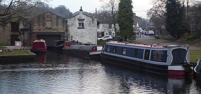
Traffic was exchanged with the Cromford and High Peak Railway which met the Peak Forest canal here. The warehouse building was built in 1801, and extended in 1831 after the railway arrived.Continue ahead across the river bridge to the canal wharf, which has picnic tables, before heading back up Canal Street - seen in the image - to the town centre and station.
Alternatively, you can continue on the canal towpath which parallels the railway to return from Furness Vale (1½ miles - not every train stops there) or New Mills Newtown (3 miles) to rejoin a train towards Davenport. You are allowed to do this on your Whaley Bridge ticket.
Comments welcome at info@davenportstation.org.uk