Davenport Station home | Index to History pages
While briefly describing the more-populated northern part of the farm, which deserves a feature of its own, here we'll concentrate in detail on the southern part, a large area of which remains grassland in 2020. The fate of the 'Shot Stall' fields to the north is related in our feature The Highfield Story, and the area around the Jolly Sailor inn, not included in Yew Tree Farm is covered by The Charlestown Story.
As usual in such a history, there are gaps in the story, which readers might be able to fill, and some guesswork.
The Farmers
From easily-accessible records, we can trace some of the people who lives and worked at Yew Tree from the 1840s onwards.The 1841 Tithe map lists the tenant was given as William Adkinson. He was still there aged 75 in 1851 (spelled Atkinson) with his wife Hannah (75) , their son John (farm worker, aged 40), his wife Elizabeth (27) and Martha Smith (25), described as grand-daughter. Also living in the farmstead were three farm labourers, Robert Moult, William Moult and Joel Thornely. The farm comprised 86 acres at that time (continued below).
Key to the tithe map
478 Croft Meadow: Meadow
479 House buildings and garden
480 Croft
481 Long Croft: Pasture
482 Lower meadow: Pasture
483 Cowfield:
484 Far marl field: Arable
485 Near marl field: Meadow
486 Coat meadow: Arable
488 Middle meadow: Arable
489 Round meadow: Meadow
490 Carr meadow: Arable
508 South Shot Stall: Pasture
509 South Shot Stall part: Pasture
510 Little Shot Stall: Meadow
511 North Shot Stall: Arable
The name 'Shot Stall' is probably a corruption of 'Shotswell' or 'Shotswall' found in ancient records of this area. Shotswell Lane was an old name for Garners Lane.
Sue Bailey writes: 'There are various ideas about the origins of the name, most leaning towards "shot" being a projecting piece of land, or a corner, angle or nook. This could fit with the fields almost being the furthest projection to the north west of the old manorial estate of Bramhall, and also the boundary with the township of Stockport.'
The Farmers, continued:
By 1861, William Atkinson had died and John Atkinson was the farmer, with a new wife, Nancy, a 'visitor' Sarah Atkinson, and two labourers, Charles Lowe and Edward Elison.
In 1871 William Chatterton was the farmer, now farming 91 acres and employing one man. His wife Mary and son William also helped with the farm, along with a niece, Ellen Clayton.
By 1881 the farm tenancy had passed to George Platt (aged 43, unmarried, born in Torkington), with two nieces Mary and Elizabeth, dairymaids, and nephew James (aged 13) Milk Boy. George's parents rented a farm in nearby Woodsmoor, although he was previously listed as a blacksmith. He was still at Yew Tree in 1891, having gathered an extended family around him, as well as two farm labourers. The Platts were the final farmers at Yew Tree, still hanging on in March 1901 by which time they would have been on the edge of the massive upheaval which was the construction of the railway through their their farmland, ending with the demolition of the house.
By 1911 James Platt, George's nephew, who had lived and worked at Yew Tree, had found himself another farm, Springfield Farm on Torkington Road near Hazel Grove, with a more modern house than Yew Tree, which still exists in 2020 as the home of the 'cats Whiskers' cattery.
With him there was his wife Emma, and two former Yew Tree residents: his mother Elizabeth, along with his half-brother Joshua who had from childhood been described as 'imbecile' or 'feeble-minded' in the language of the day.
Timeline
274 Bramhall Lane
To research every house in detail would be a large project, but with the kind assistance of its residents we can study as an example the history of no. 274 one of the two pairs of semi-detached houses built by George Knowles of 19 Dysart Street, Great Moor .The land was transferred from the Freeholders Company in 1905, and a Stockport solicitor, Frank Linnell, appears to have rented the house for a short period around 1907.
In 1908, Annie Dean Gray purchased the house known as 'Yewtree Cottage'. subject to a perpetual yearly rent charge of
£5. It was common at the time for houses to be held in the name of the wife of the family, as permitted by the 1870 and 1882 Married Women's Property Acts.
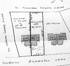
The plan from 1908 shows the original house names (r to l): Park Dene, Hope Royd, Yewtree Cottage and South View. The first pair are larger houses.
The household at Yew Tree Cottage in 1911 comprised William Martin Gray, born in 1860 in Great Yarmouth, Norfolk, (Manager of a glass and china shop), his wife of 23 years, Annie Dean Gray (aged 54, born in in Southport, Lancashire), and all four of their children: son Hazel Arthur Gray (age 22, Inspector of Electrical Installation for Municipal Corporation), daughters Elizabeth Muriel Gray (20) and Alice Hilda Gray (17), and son Donald Dean Gray (11). It seems they believed in the new concept of 'family planning'.
The Grays had left by 1914 the householder was Sagar Taylor, General Secretary of the Stockport Industrial and Equitable Co-operative Society, based at 42 Chestergate. By 1910, the Society operated 24 grocery shops in Stockport, which eventually included the branch in Davenport at 214 Bramhall Lane, which in 2020 houses the Co-op Funeral Service.
The Taylors moved to 'Yewtree Cottage' from their previous home at 9 Moorland Road in Great Moor some time after 1911, and immediately re-named it 'Rivington' after a beauty spot close to their first married home at 105 Chorley Road, Horwich, Lancashire. Born in Rawtenstall, Lancashire, in 1872, Sagar had started work as a Grocer's Assistant in Rawtenstall, then worked as Secretary to the Horwich Industrial Cooperative Society before moving to the post in Stockport. His wife Martha was born in 1869 in Shawforth, a village near Rawtenstall. They had a daughter, Gwendoline, born in 1904.
In 1921 Sagar Taylor stood as a Co-operative (supported by Labour) against the sitting Conservative member Samuel Lees for Edgeley Ward in the Stockport Council elections, but was defeated.
Sagar died in 1924, aged just 52; his wife Martha Hannah Taylor was still at 'Rivington' in 1934. according to Kelly's directory.
She died at 'Caravan', Wayside Drive, Poynton, on 8 March 1941, aged 73.
In 1935 the house was sold, as an investment rather than a home, to John Stanley Lowe. He lived in Charlestown Road West, and sold dairy products from a shop at 193 Bramhall Lane; his story is told in our Walton's Terrace feature.
The National Register taken in 1939 listed no. 274 as 'vacant' as seen in the extract below.
However, the Register, which was used to issue Identity Cards, continued to be updated throughout the War and until 1952 when cards ceased to be issued, and beyond. (By that time some of the pages had required repair with tape.) No. 274 has 'Miss Travis' written in at a later date.
'Miss Travis' remained a mystery until 2022 when I felt able to visit the Stockport Heritage Library and have a session on the microfilm of the 1950 Electoral Register which lists, at 274, Mary T. Travis, and also the names of three men; John H Fox, Wilfred Needham and Harold Male. Clearly, she was renting the house from Mr Lowe, and operating as a boarding house for single men, a common actvity at the time.
Her first name and initial allowed me to visit the 1911 census, which found, living at 143 Grenville Street, Stockport, Mary Theophila Travis, aged 24, with five younger sisters, daughters of William James Travis, a milk dealer, and his wife Mary Travis. By 1921 William had died; his widow Mary and daughters Mary Theolphila and Emily were continuing the milk business.
The unusual name led us to a North Wales newsaper from 1979 recording the death of Mary Theophila Travis, aged 93, of 55 Llandudno Road, Rhos-on-Sea, born in Stockport, who had lived in the town for 20 years. This means she retired to the Llandudno area in 1959, perhaps that was when she left No.274.
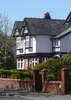
In 2020, now simply 274 Bramhall Lane, the house still retains its well-kept Edwardian style, and looks to be good for many years more. The name 'Yewtree Cottage' has somehow become attached to no. 280.
Householders 1911
--[Ashfield Road]--
218 Jolly Sailor Hotel
220 Alice Agnew, Carlton House School
222 'Ealsdene'. James Rennie (52, born in Glasgow) Commercial traveller, soap maker.
224 Walter Woodruff (37) Chemist. His shop was at 3, Woodford Road, Bramhall.
226 'Fairhaven'. Mrs Annie Baxter (55), widow of Stockport-born Joseph Baxter, head of letterpress printing firm Joseph Baxter & Co.
--[Barnfield Road]--
[Land owned by Samuel Kay]
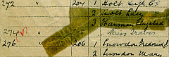
270 John Edwin Mercer (54), Millinery agent and manufacturer
272 Ambrose Brook Sunderland (65), Artificial flower maker
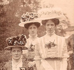
Sunderland and Mercer were partners in an artificial flower manufactory, established c.1884 at Stoneswood Lower Mill, Todmorden. Their products adorned women's bonnets, such as those displayed in the picture above from our family archive. They were well-known citizens in the town of Todmorden, why they came to Davenport is not known, perhaps related to some hatting connection. The firm itself seems to have lasted until 1924.
274 William Martin Gray, shop manager, glass and china
276 Frederick Jacob Snowdon, Commercial Traveller (biscuit representative)
The houses 278 to 286 were built by in 1911-13 after the date of the Census, by Stockport-born housebuilder James Crosby, who (in the name of his wife Emily Gwynne Crosby) bought all the plots from the Freeholders Company, and also created 'Yew Tree Road' from the former farm entrance, building houses 1, 3 and 5. The Crosby family lived nearby at 7 Ashfield Road.
It appears that they sold all their Bramhall Lane houses to members of the Schofield family, ironfounders of Ashton-under-Lyne, who saw the benefits of investing in property. Some residents as listed in a 1914 directory are below.
278 Bernard Joseph Hood, Confectioner (employer)
280 Stanley Turner
--[Yew Tree Road]--
282 Charles Turner
284 Mrs Matthews
286 ?
[Railway bridge]
Internet Sources
Ancestry.co.uk
British Newspaper Archive
Cheshire Tithe Maps
The Guardian online (Manchester Libraries)
The Land Registry
National Library of Scotland maps
Google Maps
Old-Maps.co.uk
Street directories on our website
Todmorden and Walsden website
Horwich Heritage website.
Thanks
Thanks are due to the residents of no.274, and also to fellow local historian Sue Bailey whose researches reach back over the centuries.
Our access to the railway photographs of the late Wallace Sutherland is entirely due to the generosity of Mrs Tril Sutherland.
Comments welcome: charlie@davenportstation.org.uk
Origins
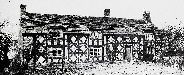
Yew Tree Farm was one of a number of tenanted farms which formed the estate of the Davenport family of Bramall Hall. It comprised 91 acres of land on the western side of Bramhall Lane between Garner's Lane and today's North Park Road, although its eastern boundary for much of the way was separated from the road by narrow fields belonging to Mile End Farm. (There was access from the Lane to the northern end of the farmland by a track which later became Oakfield Road.) The farmhouse was adjacent to Bramhall Lane, entered by what is now Yew Tree Road. Unlike several of the farmhouses in the area, it was never rebuilt or replaced, just 'patched up' by replacing parts of the timber-framed walls with brick, painted to match the original.The picture above shows the farmhouse in the 1880s, when it came to the attention of Manchester-based architect Alfred Darbyshire (1839-1908) who had an interest in ancient buildings and photography. The style of the building suggests that it was as old as the oldest parts of Bramall Hall, perhaps the late fourteenth century. Local historian John Owen wrote in 1888: 'It has suffered most from neglect and injudicious repairs. It is said tnat the young squire Davenport intended to pull it down and rebuild it.' However the 'young squire' John Handley Davenport sold the house and estate in 1877, and the farm staggered on until the late 1890s when Midland Railway's new line was built across the farmland, the farmer left, and and it was demolished. What remained of the the land was initially added to the adjacent Grange Farm, and gradually sold off.
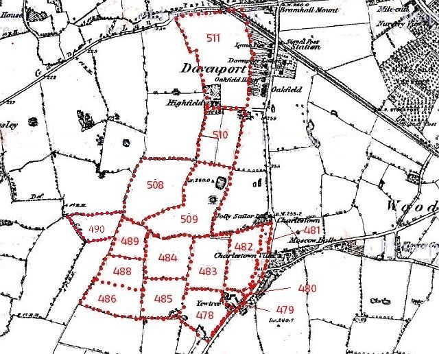
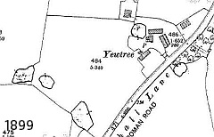
This image shows Yew Tree Farm as in the 1840s Tithe Map with its plot numbers, superimposed on a map from the 1870s. Plot 479 includes the farmhouse.
The last of the Davenports
The Bramhall branch of the Davenport family began with the marriage of John de Davenport to Alice de Bromale in the late 1300s, when it is thought that the oldest parts of the Hall were built. It was added to over the centuries; most of what can be seen today is of Tudor origin, with added Victorian 'faux-Tudor' additions. The estate, owned by the Davenport Lord of the Manor covered a wide area; by Victorian times the whole of the Township of Bramhall. The northern border was along Kennerley Road and Garners Lane, and to the east along the Manchester - Buxton road as far as Hazel Grove.The Lordship of the Manor passed down the male line for several centuries. The name William was popular: ten of the fourteen Lords up to 1869 had that name. However, the tenth William died in 1829 with no legal heir; he had two daughters by a local farm girl, and one of them, Maria, was adopted as heir. She married a naval man, Salusbury Pryce Humphries, who took on the surname of Davenport, who took on the role of Lord of the Manor which passed to Maria when he died in 1845. She was succeeded in 1854 by her son William Davenport Davenport; by this date the estate with its tenant farms was no longer prospering, and the sale of land for development began, slowly at first, and mostly at the northern end around Davenport railway station which was built in return for the agreement for the Stockport - Whaley Bridge line to cross Davenport land.
William Davenport Davenport died in 1869, when his son and heir John William Handley Davenport was just seventeen years old and the estate was governed by a family trustee. John Davenport seems not to have lived in the Hall, although initially remaining in the Bramhall area. The Hall was leased to Wakefield Christy, a great-grandson of Miller Christy, founder of the Christy hatting company, family including his brother Stephen.
The Freeholders Company
In 1876 the Christy lease on the Hall expired, and John Davenport attained his 25th birthday and became the Lord of the Manor and lands of Davenport. In the same year he married Fanny Constance Mabel Broadwood (of the Broadwood piano-making family), who apparently was not impressed by the ancient Hall. It was resolved to sell it and leave Bramhall. In May 1877 a four-day auction of the contents took place, at which many bargains were obtained, and in August the Hall, and the whole of the estate not already sold passed to a specially created firm called the Freeholders Company Ltd, for a reported sum of around £200,000. It is likely that John Davenport himself had a share in the Company; researchers are thwarted by the fact that its offices at 15 Cross Street, Manchester were destroyed with all their contents in the 'blitz' of World War II.The Hall and its parkland was eventually sold to Thomas Henry Nevill, wealthy owner of the Strines calico printing works as a present for his son Charles Henry Nevill, who enjoyed himself by prettifying the Hall and grounds. After his death the Hall was on the market again and after failing to sell at auction was bought by businessman John Henry Davies. Eventually, in 1936, it was bought by Hazel Grove and Bramhall Urban District Council, whose successors Stockport Council own and operate it today as a visitor attraction and wedding venue.
Stephen Christy
Of all the people who purchased parts of Yew Tree Farm, one name stands out: that of Stephen Christy, who remained in the area to manage the hat factory after his brother Wakefield's departure to London. Looking for a 'stately home' for himself, he found 'Highfield', a sizeable villa which had been built around 1869 on a rectangular plot at the meeting of two of Yew Tree Farm's two northerly fields for Edward Hyde Boothroyd, a Stockport solicitor who unfortunately suffered bankruptcy in 1878 and was obliged to find a smaller home.Christy moved his family into Highfield, installing some of the items he had purchased at the Bramall Hall auction, and set about enlarging it and investing in further parts of Yew Tree Farm's land. Eventually his holdings, the development of which will be subject of a later feature, appear to have reached from Garners Lane to the brook which runs down from the Jolly Sailor Inn. The inn itself stands in a plot which had been purchased from the Davenport many years earlier by the Croft family, and was never owned by the Freeholders Company, although later owners of the inn did purchase extra land around it. The history of the area round the inn is already covered by our feature The Charlestown Story.
The Midland Railway
The smaller fields around the farmhouse have interesting stories to tell, one of which involves the Midland Railway Company, which by the 1890s had grown from a local network centred on Derby to a trunk line from London to Manchester and Scotland, competing with the London and North Western Railway's established routes. However, to reach Manchester it was dependant on the busy line from New Mills via Marple and Stockport (Tiviot Dale) to Manchester, shared with another company which was to become the Great Central. To avoid this bottleneck the Midland resolved to build a new line from a junction near New Mills to Heaton Mersey, which would be designed for fast running, with only one station, Hazel Grove (Midland), which closed not long after opening.Armed with an Act of Parliament, the engineers plotted a very direct route, requiring several impressive viaducts and what is still one of the country's longest tunnels near Disley.
The line passes under Bramhall Lane, traversing the farmland in a cutting; as mentioned above, the farmhouse was demolished. Although not in the direct route of the line its yard probably served a base for the digging of the cutting. To allow access from Grange Farm to Yew Tree's fields, a private bridge over the line was built by the railway company connecting the two parts of the farm, but it was removed in the late 1960s when the 'Midland Walk' housing development was being built.
While the line was under construction, the borough of Stockport was undergoing expansion, and the route of the line at Bramhall Lane was chosen as a new boundary, from 1901 replacing the previous one along Kennerley Road and bringing most of the Yew Tree farm land from Bramhall into Stockport. Since 1974 Bramhall has been part of Stockport.
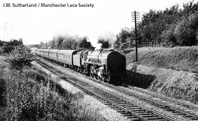
The picture above was taken in 1959 by local enthusiast Wallace Sutherland showing locomotive 70042 Lord Roberts passing through Bramhall Lane bridge with the 4pm Manchester Central - London St Pancras express. The pylon on the left is part of a high-voltage line, since removed, which ran parallel to the line on this section. A period picture of a train passing through Yew Tree Farm land, beyond the bridge, has eluded us so far.
The line opened in 1902 and for many years, express trains, including in the 1960s the 'Midland Pullman', passed that way. It proved very useful as an alternative route when the main line through Stockport and Crewe was being electrified in the early 1960s, after which the passenger service was declared redundant by British Rail and passenger services ceased, although (reduced to single track) the section through our area is still a valuable link used by stone trains from the Peak District quarries although the connection to Manchester no longer exists, the stone trains divert on to a line leading to Northenden Junction on the Stockport - Chester line. The section from Hazel Grove to New Mills carries passenger trains again, since a connection to the Stockport - Buxton line was created in the 1980s.
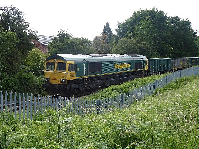
In Summer 2020, this train of stone-carrying wagons is crossing what was once 'Middle Meadow' heading for the Tunstead quarries.
At the time of writing this there are proposals 'on the table' to bring back passengers to the section through Davenport as far as Hazel Grove by connecting it to the Metrolink tram system at East Didsbury, and use 'tram trains', of the kind in use in Sheffield, which can share the track with freight services. Details such as whether the line would be returned to double track, how it would cross the river Mersey, and where any stations would be located, remain vague. Pessimistic visions arise of treasured green space converted to car parks.
Housing Developments
From around 1900, houses in the 'arts and crafts' style of the time began to appear on Yew Tree Farm land along the frontage of Bramhall Lane, most of them architect-designed, although some of these at the northern end are on land that was formerly part of Mile End farm.Barnfield Road was laid out in the 1890s by James Lamb, then owner of the adjacent Jolly Sailor Inn, and in 1904, by which time the inn and land had been taken over by the Daniel Clifton Brewery, a few houses were built on the north side and on the corner with Bramhall Lane.
South of Barnfield Road, a long plot of land fronting Bramhall Lane had been purchased by Samuel Kay, of Charlestown House, and only after his death and the sale of his land in the late 1920s were houses (1 Barnfield Road and 250-268 Bramhall Lane) built there. Kay also owned plots of land on the other side of Bramhall Lane around the Woodsmoor Lane junction, which was developed for housing at the same time.
To the south of Kay's land, a plot of Yew Tree Farm land adjoining Bramhall Lane was acquired in 1905 from the Freeholders Company by Stockport-based builder George William Knowles, who built two pairs of of large and elegant semi-detached houses (270-276 Bramhall Lane).
A map dated 1909 shows them as the only houses between Barnfield Road and the railway line; the site of the farmhouse itself remained undeveloped until a few years later when Yew Tree Road and its associated houses were built. Nos. 278 to 284 Bramhall Lane, completing the development as far as the railway bridge, were in place by 1914. In 1912 that part of the road was widened, despite local protests against the destruction of trees, and the houses lost part of their front gardens.
The 1930s saw a great expansion of house-building in the Davenport and Adswood areas, both by the Council and private builders. In Adswood, a large council estate was developed, and someone in the Council thought it would be useful if there was a through road connecting that area with Bramhall Lane, avoiding the centre of Davenport. To this end, one of the new roads, off Garners Lane, was named 'Barnfield Road West' and the existing cul-de-sac Barnfield Road gained the suffix 'East'. However, perhaps due to the war, and/or other plans for the area, the connection between the two was never made, and anyone who arrives at on the 'wrong' section is faced with a long detour.
Barnfield Road Allotments
Of the area behind the houses, a portion initially remained
as farmland worked by Grange Farm. In 1921, a subcommittee
of Stockport Council, the Small Holdings and Allotments
Committee which was tasked with making enquiries as to
suitable areas of land to be used for allotments, inspected
the site and resolved to purchase (using a loan from the
Ministry of Agriculture) for £1552.10.0 just over 20 acres
for use as 'smallholdings', small farms which would each
support one family. The idea had become popular after World
War I as an occupation for servicemen returning to civilian
life. The chosen area included the all the remaining un-developed farm land between the brook and the railway line, with access from the end of Yew Tree Road. In some other places around the UK, small houses for the smallholders were built on the plots, and plans for suitable cottages were prepared by the Borough Surveyor. However, the early applicants for plots already had homes, and it's not clear what was built. The area was not mapped in detail by the Ordnance Survey until the 1960s, when the word 'smallholdings' appears for the first time. A structure is shown amid trees next to the railway with what may be outside toilets nearby; it is still shown on a map of 1985. Does anyone remember it?
As time went on, smallholdings became less popular, and by 1930 part of the site adjacent to Barnfield Road had been divided into smaller plots as 'allotments.' In later years the allotment area was increased to reach the end of Barnfield, while the rest of the former smallholding area, including an orchard which seems to have been part of a market garden enterprise, has been happily left to nature, apart from a small field and football grounds at the western end, even though the word 'smallholdings' still appears on current maps.
The Playing Fields
We were first writing this 'in lockdown' during the 2020 virus crisis, when people are allowed outside to walk or cycle for exercise once per day. The residents of Davenport and Woodsmoor are fortunate in having several large areas of playing fields a few minutes walk away. The expansive Davenport playing fields, part of which lie on the land of Yew Tree Farm, with their three football pitches as well as extra grassland and the old woodland round the edges, are ideal for the purpose.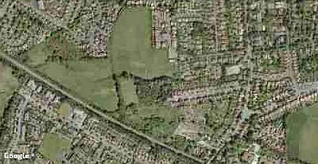
For this superb facility we have to thank the relatives of Stephen Christy (senior), who died at 'Highfield' in 1890 leaving an estate worth a remarkable (for the time) £253,284 to his family and charities.
The fields (part of field 509 and other adjacent land) were donated to Stockport Council with the proviso that they should be playing fields for the community. The donor was Lieutenant-Colonel Sir Geoffrey Christie-Miller, son of Stephen Christy's brother Wakefield who, in addition to the hat manufactory, had inherited lands and wealth from another branch of the family on condition that he added the name Miller to his surname, and so became Wakefield Christie-Miller, 'Christie' being the more common version of the Irish 'Christy'.
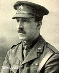 Geoffrey Christie-Miller was born in 1881,
and was educated at Eton and Oxford University; in 1911 he
joined the Christie hatting firm. In 1906 he received a
commission with the Buckinghamshire Volunteer Batallion; he
served in World War I with the Oxfordshire and
Buckinghamshire Light Infantry, and in 1916 was awarded the
Military Medal. In 1908 he married,
at St George's Church. Stockport, Kathleen Olive
Thorpe, eldest daughter of the Vicar, Rev. J.H.Thorpe. The
family home from 1911 was Stapeley House near Nantwich in
Cheshire. In 1946 he entered the Knighthood as a Companion
of the Order of the Bath; amongst other public duties he
served as Chairman of the Governors of the Stockport Grammar
School from 1950 to 1962. He died in 1969; his son John
Aylmer Christie-Miller maintained the Stockport connection
until his death in 2007.
Geoffrey Christie-Miller was born in 1881,
and was educated at Eton and Oxford University; in 1911 he
joined the Christie hatting firm. In 1906 he received a
commission with the Buckinghamshire Volunteer Batallion; he
served in World War I with the Oxfordshire and
Buckinghamshire Light Infantry, and in 1916 was awarded the
Military Medal. In 1908 he married,
at St George's Church. Stockport, Kathleen Olive
Thorpe, eldest daughter of the Vicar, Rev. J.H.Thorpe. The
family home from 1911 was Stapeley House near Nantwich in
Cheshire. In 1946 he entered the Knighthood as a Companion
of the Order of the Bath; amongst other public duties he
served as Chairman of the Governors of the Stockport Grammar
School from 1950 to 1962. He died in 1969; his son John
Aylmer Christie-Miller maintained the Stockport connection
until his death in 2007.In the 1960s Davenport School was built, in the functional style of the time, on the edge of the fields, reached by a new street of houses named Highfield Close. Initially a 'secondary modern' and later a 'comprehensive'. the school flourished in the era of the 'baby boom' but there is no trace of the buildings today; it has been replaced by houses. Its story awaits the creation of a further article.
The By-pass Road
From the early 1960s, a series of reports were produced on the theme of relieving road traffic in the Stockport area by the building of new motorway-standard roads, one of which was to be a 'Stockport North-South By-pass'. Early ideas envisaged a length of road relieving the A6, which would have run from Heaton Norris to Stepping Hill around the west of the town, with much demolition in the Edgeley area, then across the Davenport playing fields, and crossing Bramhall Lane (no doubt with a large roundabout) somewhere near Barnfield Road East. The road would have crossed what was then the Davenport Golf Course. Faced with this possibility the golf club moved to Poynton; when that route proposal was eventually abandoned, its land was sold to the Wimpey company to build the Bracadale Road housing estate.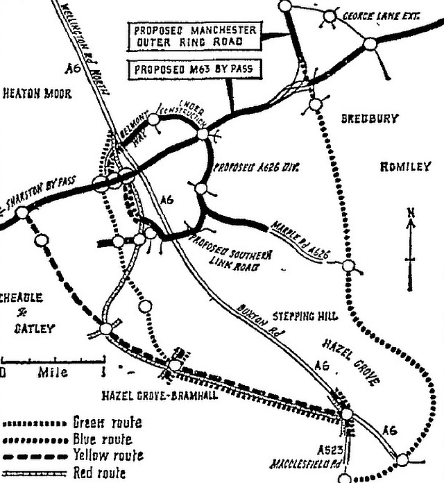
When the Midland railway line closed to passengers in 1967, the planners saw an opportunity to replace it with a road, so the plan was amended to follow this, again making use of the Davenport playing fields. The new road would have joined the A6 and the A523 by the Rising Sun inn south of Hazel Grove. Bramhall lane South would be crossed by a 'two-level roundabout junction. The drawing above, published in 1973, shows suggested options; the 'green route' appears to impact drastically on the Davenport area.
The immediate result was a 'planning blight' on the houses near the railway bridge which lasted for a number of years until British Rail made it clear that the railway was a vital link for stone trains, so nothing happened. The proposals did incidentally protect the playing fields from development. More recently, something like the 'blue route' on the plan has been selected, controversially running through the scenic Goyt Valley.
The 1960s
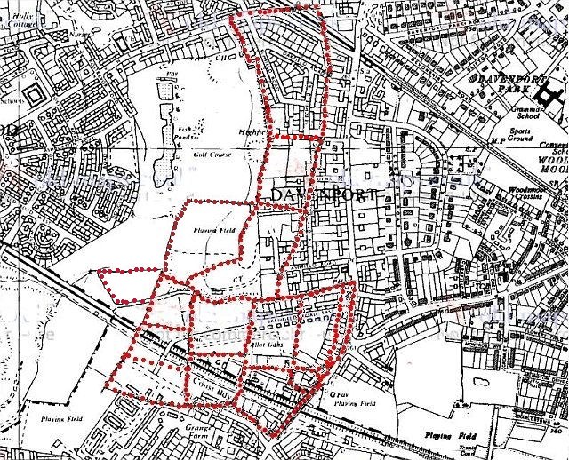
The field boundaries transferred to a map dated 1965. Notice how the boundaries of the northernmost field were mostly adhered to by the house builders. If you walk down the path from Garners Lane to Blaven Close you can see the 'kink' in the boundary.
The golf course shown on the map, dating from around 1916, was created on the the site of the abandoned Davenport Terra Cotta Brick and Tile Works; shortly after this map was made, the Davenport golf club re-located to Poynton, and when the threat of a by-pass receded, they sold the land to the Wimpey company for housing.
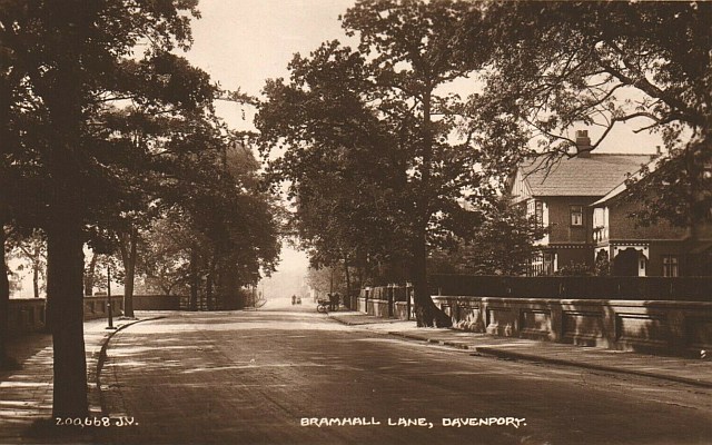
This postcard view of Bramhall Lane in the 1920s looks towards the Midland Railway bridge and Bramhall. The house in view is no.270 Bramhall Lane.
Printed Sources
Fran Cox, Barnfield Road Allotments Stockport, Origins and History to 1930. PDF file, published on-line, 2013.
E. Barbara Dean, Bygone Bramhall: Aspects of Change in a Rural Community. Stockport Council Recreation and Culture Division, 1980.
E. Barbara Dean, Bramall Hall: The Story of an Elizabethan Manor House. Stockport Council Recreation and Culture Division, 1977.
Written by Charlie Hulme, May 2020. Latest updated August 2022